Historic (?) Southeast Storm Could Be Next Northeast Snow Threat

Overall pleased with the forecast for the current storm for the Big Cities. Definitely underestimated parts of CT that saw 8-16″ of snowfall on average in the western part of the state, even down to New Haven County. Just a reminder… State of Occlusion is on Facebook. I’ve posted some additional cool links and snow maps early on that page. “Like” the blog by clicking here! On to the fun…

The Eastern 2/3 of the US are going to be peppered by winter events over the next five days or so. Let me run through things here.

Snowfall Forecast from Friday Overnight-Sunday Morning

First off, tomorrow, as all of the energy responsible for the unsettled eastern weather the last couple days starts to slide offshore, it will begin to develop into a nor’easter, but rapidly exit to the east. However, as it intensifies, it could produce a pretty well organized band of snow from about Southern NJ/Central DE through E Long Island and possibly Cape Cod. The snow map is over to the left if you want to enlarge it and see my thoughts through Sunday morning. Not a big storm, but there could be some heavy snow for an hour or two, especially east of Rt. 206 in NJ as the storm pulls away. Lingering snows will produce perhaps a couple more inches in New England, with upslope areas of the Green Mountains and Berkshires more favored. I don’t believe accumulations will be that high. There is some chance the Cape and Islands, as well as the Boston area may see some enhancement too.
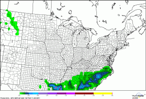
GFS Forecast of Total Ice Through Tuesday Morning (Credit: wxcaster.com)

That will exit tomorrow night and by Sunday morning or so, things will be quiet. But that sets the stage for the next event, and this one might be an absolutely punishing doozy of a storm. The map to the right shows the GFS forecast for total accumulated freezing rain through Monday. A strong storm system is going to trek across the Southeast in an unusually cold air mass, and with it will come plenty of moisture…almost an El Nino type storm. Winter Storm Watches are posted almost to the Gulf Coast for Mississippi and Alabama, and for most of northern Georgia and Louisiana, as well as Arkansas. This amount of ice this far south would be absolutely crippling…that isn’t hyperbole either…these are places that almost never see frozen precipitation of any kind, let alone to this extent. The raw model outputs in some of these places is absolutely mind boggling. Atlanta is showing anywhere from 6-12″ of snow, with 1/4″ of ice! Of course, that’s raw model and has to be taken with a grain of (road) salt. But still, that’s absolutely insane, The all-time snow record for Atlanta is (I believe) 10″ in January 1940. It’s tough for me to put this in historical context, as I’m not THAT familiar with Southeast wintry climatology, but this would be, from a meteorological perspective, one of the most incredible things we’ve seen over the last couple winters (and we’ve seen a LOT). Check out the total snowfall forecast through Tuesday morning in the Southeast below (from http://wxcaster.com/regional_snowfall.htm).

Southeast NAM Snowfall Forecast Thru Monday Night (Credit: http://wxcaster.com/regional_snowfall.htm)

The next question becomes, where does it go? The three main models to look at for tonight, taking them (since the NAM only goes out 84 hours) to Tuesday morning shows the low sitting somewhere off the northeast South Carolina coast. Not surprisingly, where this storm sets up, will determine how it impacts areas up the coast. The European model sets up the furthest northwest. Not surprisingly, as you run it out further in time, the European delivers a quick moving, but solid snow event (6-12″ish) for most areas from I-95 south and east. The GFS is a glancing blow, but mainly a miss (not bad for New England). The NAM stops at hour 84, but is a little closer to the European model than the GFS. So my feeling is that despite model flip flopping the last couple of days, we could still see a pretty potent little storm from the Carolinas up into New England. The timing on the snow would be later Tuesday to the south, ending Wednesday from Jersey through New England. Stay tuned on this, especially if you have midweek plans. I’ll do my best to keep you posted.


Norlun Troughs?

Going to get a little technical briefly. Going to put this pretty plainly: What’s coming Friday will more than likely not be forecasted very well. Why? We’re dealing with a phenomenon that’s pretty common in the Northeast in winter…it usually rears its ugly head at least once. We call this an inverted trough…Norlun trough…or instability trough. What is it? Well, typically, when you think of an atmospheric trough, you think of a “U” or “V” shaped pattern. In an inverted trough, this, well, inverts. It looks more like an upside down U. The lower pressure, or lower heights end up on the north side, rather than the south side. These sorts of setups can produce some nasty weather, heavy precipitation, and thunder.

Here’s more info on Norlun troughs (recognized in the 90s and named for the meteorologists who discovered it).
A technical paper on Norlun trough events.
And here’s more on inverted troughs.

So what’s it to you? Well, the models are beginning to hone in on how this storm on Friday and Saturday is going to behave. And they are indicating that an inverted/Norlun trough type setup may occur. The bottom line is that there will be snow. The question is twofold: Will the Norlun event occur, and if so, where will it setup? This morning’s models pegged it right over North Jersey and NYC. This evening it looks to be shifted a little further north. This is important, because outside of the Norlun trough there will be a generic sort of snowfall. But under the narrow Norlun trough, there should be significant snow, with the possibility of thundersnow and more.

Right now, the NAM model (a mesoscale, small scale, higher resolution model) is showing extremely heavy snow (and has on three straight runs today) for areas immediately north of NYC, Long Island, the Catskills, and the Western Mohawk Valley. The GFS model is suggesting this will be further north and east into New England and the Adirondacks.

Latest Snowfall Risk Assessment for Friday and Saturday

So my snow “assessment” has a broad area of potentially significant snow showing in red. I right now have this from about the Bronx, east-southeast into Long Island (yes, that places the division of snow vs. heavy snow within NYC). It stretches up into the western Hudson Valley, Catskills, western Mohawk Valley and southwestern Adirondacks. I also include much of southwest Connecticut as well, including Bridgeport and New Haven. The problem is that it’s next to impossible to pinpoint exactly where within this idealized zone the prolific snow will be. The yellow territory indicates the basic “cone of error” of sorts. I don’t foresee the risk of heavy snow shifting south of NYC much, if at all. The risk to me is clearly on the northern and eastern sides. This could shift further north, so the axis of the heavy snow stretches from Syracuse/Utica through Albany, the Berkshires, and Central Connecticut to the coast. And it could even shift further north too.

The heavy snow band will be awesome though, with extremely heavy rates of snow, likely some thunder, lightning, and whiteout conditions. I could see max amounts of 10-15″ in this band. You will only need to go a few miles from that core of heavy snow however to find amounts of 6″ or less…that’s the type of storm we’re looking at: Very narrow gradient, very sharp gradient, with extremely variable snowfall totals. Thus, this makes forecasting this system extremely difficult, if not impossible at this point. So if you live from NYC into Central New York and all of Southern New England, stay tuned. As I said, the forecasts for this will more than likely be challenging, vague, and possibly even wrong initially. But that’s the story.

Outside of the heavy snows, expect a brief period of maybe some heavy snow, with a coating or so, up to about 3″ in spots across much of NJ, PA and central New England. Closer to the heavy snow axis, there may be some 3-6″ amounts. But those will be isolated.

New model data indicating the possibility still of a major snowstorm Tuesday of next week. There are still a multitude of questions as to whether it will track in the sweet spot for a DC-Boston hit, as tonight’s GFS is showing, or if it will pass further south. More on that after this first event passes.

———–

Don’t forget, State of Occlusion is on Facebook! I’ll post some additional cool links and snow maps before they’re published here on that page. “Like” the blog by clicking here!

Hurricane Season Ends, European Chill, Cool Video, Quake Off Jersey

Well, I hope everyone enjoyed their Thanksgiving and holiday weekend, did their shopping, etc. Back in California after a fun leg of flights today over the large storm system swirling in the middle of the country. More on that shortly. First, let’s catch up on some of the more interesting stories from the last week or so…

2010 Atlantic Hurricane Season Storm Tracks - courtesy NOAA

2010 Atlantic Hurricane Season Ends

First and foremost, today is November 30th, which is the last day of the Atlantic Hurricane season. That isn’t to say more storms can’t form, but in terms of statistics, this season is done. How did we do?

19 Named Storms
12 Hurricanes
5 Major (Cat 3+) Hurricanes

Normal is 11, 6 and 2 respectively. Here’s the official NOAA press release on the season. The season ends up tied for the 3rd most active on record (1887, 1995), and it ties for the second most hurricanes on record (1969). The money quote from the release (in my opinion):

“Large-scale climate features strongly influenced this year’s hurricane activity, as they often do. This year, record warm Atlantic waters, combined with the favorable winds coming off Africa and weak wind shear aided by La Niña energized developing storms. The 2010 season continues the string of active hurricane seasons that began in 1995.

But short-term weather patterns dictate where storms actually travel and in many cases this season, that was away from the United States. The jet stream’s position contributed to warm and dry conditions in the eastern U.S. and acted as a barrier that kept many storms over open water. Also, because many storms formed in the extreme eastern Atlantic, they re-curved back out to sea without threatening land.”

KTRK-TV in Houston compares some of the seasonal forecasts.

Some more perspective on the season and hurricanes in general, including a neat satellite derived rainfall map from this season.

Overall,  I think this season is going to go down in the books as a bust in general, namely because the U.S. was spared a hurricane hit for the fifth straight year, despite the hyperactive nature of the season. But the forecasts were very well done for the most part this season, and frankly, I don’t know that you can ask for much more than that, given our limited ability to predict weather and climate.

So what about next year? It’s obviously way down the line and there’s little skill in trying to make a forecast this far out. But, if you look at a couple of key El Nino area forecast, the ECMWF and the IRI, both indicate (an implied and/or average) weak La Nina persisting into next summer. Should that hold together, that would be one factor that would would favor another busier than normal season. Whether it’s even remotely as busy as this year…or busy at all…remains to be seen though. But that just gives you an idea.

Lastly with the tropics, some new online maps are available, indicating flood vulnerability along the coast due to storm surge. If you click the link in the article and tool around with the maps, some of them are interesting. Bottom line, there are a LOT of vulnerable places on this country’s coast to storm surge flooding.

Mildly similarly related…

There was an interesting article published in Friday’s New York Times about how Norfolk, VA is handling frequent bouts of tidal flooding.

Some cool video came out of last week’s big Western storm. This video was courtesy of Dale Ireland in Silverdale, WA (originally published in Cliff Mass’ Washington weather blog). Then of course, there was this priceless video from Seattle last week:

Here’s a radar loop from the snow in Seattle last week as well:

That Seattle snow made it to Salt Lake City last Tuesday, and here’s some really cool time lapse video of the snow rolling in, and a slower video that shows basically a wall of angry weather arriving:

Interesting AccuWeather blog post today about how the West is seeing absolutely phenomenal early season ski conditions…some of the best in years. It has been stormy…and it’s also been cold, helping a lot of ski resorts add more white gold to their slopes. Absolutely great conditions out West this year. Here’s an article on how citrus growers in Central California have been protecting their crops.

Cold in Europe

This winter is behaving (in some regards) oddly similarly to last winter. If you remember last winter, the US and Europe had it especially rough. Well, Europe is off to the races this winter too.

A few inches of snow for London…and a lot of travel disruptions.

The snow is disrupting school and life in the UK.

This follows some of the coldest November temperatures on record in the UK over the weekend!

Sweden is also seeing some of their coldest November weather in years.

The Eastern US will taste some cold weather, sort of driven by similar factors (and relatively, not nearly as cold) as we go through the next ten days or so. The pattern will also be ripe for the potential for at least some snow. More on that in coming days.

A few final things today.

USGS "Did You Feel It?" Map from today's 3.9 magnitude earthquake off Long Island.

From the head scratch department, dust storms can occur in the Arctic…and there’s an interesting driver behind them.

A 3.9 magnitude earthquake occurred around 10:45 AM today, about 120 miles ESE of New York City. The details on the quake are here. A ton of “Did You Feel It?” reports were received by the USGS from Long Island, New England, and New Jersey. Anyone notice this today?

And finally, in what is the most painful story of the day, another tornado hit Yazoo City, MS this morning. If you recall, Yazoo City was hit by a devastating EF-4 tornado back in April that killed 10 and injured dozens. From what I’ve read thus far, there were six injuries from this morning’s storm. More details if I get them.

More on some of the upcoming weather in the next couple days as I get myself caught back up on things after the extended weekend.