There’s no question that Sunday’s Packers/Niners game is going to be painfully, brutally cold, and it will most likely crack the list of 10 coldest games in NFL history.
According to NFL.com, the coldest game in history was the Ice Bowl on December 31, 1967, also at Lambeau of course, with a temperature of -13°. The second coldest was 1/10/82 at Cincinnati between the Bengals and the Chargers, with temperature of -9°. And #3 all-time was Chiefs/Colts in Kansas City on 1/7/96, with a temperature of -6°.
So for it to be the coldest ever, it would need to be -13° during the game. For it to crack the top three, we’d need to have a temp of -6° during the game. Can we do it? Let’s examine the evidence.
The game is scheduled to kick off at 3:40 PM local time. Weather models and data are frequently in Greenwich Mean Time or Zulu (Z) time. Accordingly, this game is slated to kick off at 21:40Z. Assuming an average NFL games lasts roughly 3 hours, we’ll examine temperatures in the 21Z to 00Z timeframe.
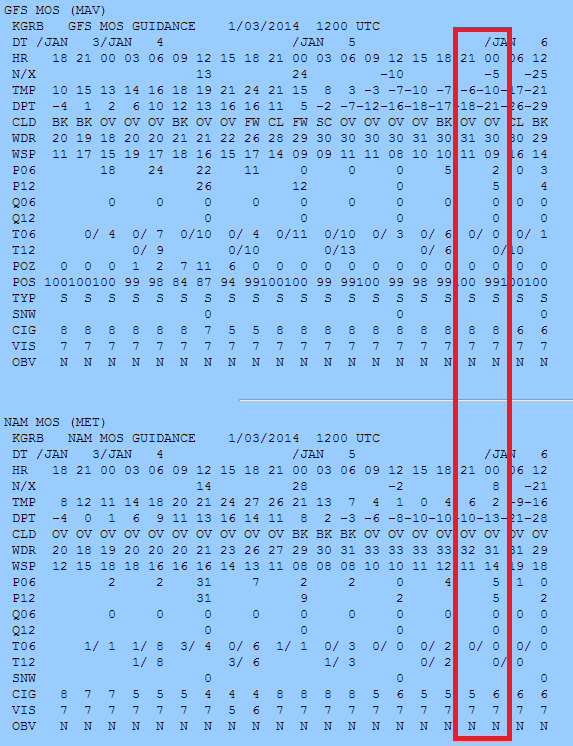
First off, the bane of most weather forecasters is MOS (model output statistics). It takes weather models, applies statistical algorithms, and produces a temperature, precip, cloud cover, etc. forecast based on the model and history. Sometimes it works nicely, but a lot of times it can be less than stellar. Anyway, looking at the two primary models’ MOS forecasts from this morning:
I have highlighted the key times. The GFS model (top) is showing temperatures falling from -6° to -10° during the game. The NAM model however disagrees substantially and is quite a bit warmer, with temperatures dropping from +6° to +2° during the game. Worth noting: If you look at the far right numbers (-25° top and -21° bottom), that indicates the the models are only four degrees apart for the Monday morning low temperature in Green Bay. So the issue is timing. The GFS is faster bringing in the Polar cold to Green Bay than the NAM model, which is a few hours slower.
A higher-resolution version of the NAM model is run also. It goes out 60 hours (vs. 84 hours like the normal resolution version the MOS output is derived from). Looking at that from the PSU E-Wall:
The map above is for 00z (or right around the end of the game). It shows temperatures just approaching 0° west of Green Bay (I circled the Green Bay area). So add another to the slower/”milder” camp. Incidentally, the European model (considered the gold standard of weather models) is somewhat between these two, with temps dropping to somewhere in the -2° to -5° range during the game.
And the last thing I will show you is what the SREF, or short-range ensemble forecast spread in temperatures is for Sunday afternoon. This is a suite of a bunch of short-range models, all with different parameters to create a cluster or consensus forecast.
The black line in the “middle” represents the mean of the various models averaged together. That mean forecast is for temps to drop from roughly -6° to -9° during the game. Note that leading into the gametime period, it does appear the model consensus splits into two camps…a milder one and a cold straight through one. The bigger cluster heading into the game window appears to be near the mean or just milder. So the mean is probably a fair representation of this model.
So, with all this being said, will Sunday’s Packers/Niners Wild Card matchup be the coldest NFL game in history? Most likely not. However, there is at least a reasonably small chance it could be if things come together perfectly. The GFS model does tend to rush certain air masses and weather systems, so I would be apt to lean warmer than it, but colder than the NAM model. This would put me at something like -3° to -1° at kickoff and maybe -7° to -5° at the end of regulation.
Either way, it should be a memorably cold game that’s something of a throwback or relic to old school football.
Here’s just an updated forecast on Thursday and Friday’s home openers.
Opening Day Thursday
Detroit at NY Yankees Atlanta at Washington
Still looking at clouds, chilly temps, and scattered showers. I think NY is safe right now, but there are some signs that rain will envelope DC before game’s end, so keep an eye on that.
Milwaukee at Cincinnati
Still looks: Partly cloudy to mostly sunny and generally in the 40s.
LA Angels at Kansas City San Diego at St. Louis
Still tracking a shower threat in KC. But those look more hit/miss, so I’m not anticipating any major disruption. Saint Louis looks pretty solid with sun and clouds. I’d take mention of showers out.
San Francisco at LA Dodgers
5 PM local time for first pitch at Chavez Ravine, and it will be postcard LA weather. Sunny, with temperatures probably 85-90 for first pitch, slipping into the upper 70s by the end of the game. Second place “Pick of the Weekend.”
Friday’s Home Openers
Minnesota at Toronto Baltimore at Tampa
Dry and 70s…dome sweet dome.
Houston at Philly
It still looks like the worst of the weather will be in the morning in Philly. The snow/rain will lift into New England during the afternoon. It will be cold, breezy, raw, damp, gross. Should be some flurries around. Despite the fact that the worst will be long gone by game time, I would label this game as a risk to be rained or snowed out though, just because of how miserable the weather will be.
Pittsburgh at Chicago
Mostly cloudy here with some rain showers likely. I doubt it’s delay inducing stuff, but it may make Wrigley an unpleasant experience…sort of a raw, damp day.
Chicago at Cleveland
Still looks partly cloudy here. Looks like low 40s…a pleasant day for baseball, but still a bit chilly.
Boston at Texas
No changes in the ideas here either, except it could be a couple degrees warmer…low to maybe mid 80s in Arlington Friday. The Red Sox will be happy they’re opening there and not in Boston.
Arizona at Colorado
Not what you’d expect in Denver for baseball this early. Sunny, mild, and temps in the low 70s. This is the State of Occlusion “Pick of the Weekend!”
NY Mets at Florida
Taking out any mention of t’storms here. Looks good for the Mets/Fish. Temps upper 70s/low 80s at first pitch.
Seattle at Oakland
Partly cloudy after a nice day when highs should push into the 70s. We’ll see temps around first pitch in the 60s, easing back into the low 60s or upper 50s at game’s end.
Northeast Snow
The map to the left is this morning’s GFS model forecast for snow in the Northeast from Earl Barker’s model website. This is a pretty significant storm, for any time of winter, let alone early April. The GFS forecast is reasonable. Here’s how it breaks down.
NYC-Philly-DC: AM Rain, perhaps ending as some steady snow north and west, with a little coating possible there, and maybe some flurries into the cities.
Northwest NJ/Sussex County: Snow to rain to snow. Ending as a slushy 1-3″ accumulation I think. Higher elevations there could see snow continue longer, and there is definitely a risk that higher snowfall totals occur here. Still model disagreement in this area.
Boston: Mainly a mix in the city, but they could get 3-6″+ just north and west.
Interior CT/MA/Albany: 6-12″ easily, with higher amounts in the higher elevations. Some of those higher terrain areas may see 12-18″ of heavy, wet snow.
Interior NY west of I-87 to I-81 (Albany-Syracuse): Gradually diminishing snowfall gradient of 6-12″ near ALB to 1-3″ near SYR…. 5-10″ for Binghamton/Scranton.
This is just based on a cursory glance, so expect some changes, and refer to the NWS for the most local info. Either way, we’re looking at a large storm, with strong winds possible in New England as well, that could lead to power outages and downed trees/power lines. Just brutal for April.
Trying to hit a few key issues today. First, the potential for accumulating snow in the Mid-Atlantic over the weekend. It’s snowed, sleeted, thundered, etc. across much of the Mid-Atlantic and Northeast in the last 36 hours…why not add something else to the mix?
Map to the left is the NAM model depiction of snowfall for the next 72 hours. It shows you snow stretching from Omaha to Kansas City to St. Louis to Louisville to Cincinnati to just south of Washington, DC. This has been shown off and on throughout the week on all the models. It looks like we’re game on for a snow event. The problem is (of course) the exact storm track. The GFS forecast is *slightly* further north, which would bring more snow into DC and much less around Richmond. I would side in between the two right now…with light snows south of Baltimore to south of Richmond, with an axis of heavier snow, probably in the middle, through, say Fredricksburg, VA. Could be a decent event for the northern part of the Blue Ridge. This will not be a *major* event, but given that it’s almost April, every snow event is extra painful.
So if you have weekend plans, specifically Sunday, keep this in mind. It is the time of year where it’s tougher to get snow to stick on the roads, but given that we’re leading into this event with several cold days, we could see more sticking than we normally would in late March.
In other news, spring may be delayed somewhat in the East. Just got a look at the latest weekly forecast from the European model…and, yeah, it looks cold if you live anywhere north of about Florida. Not guaranteed to verify, but this is certainly not what you want to see if you live in the Northeast, Plains, Great Lakes, or Mid-Atlantic.
However, this may help slow snow melt some over the northern tier…which is good because the latest river forecasts show major flooding likely on the Mississippi near St. Paul. Could be another painful Upper Midwest flooding season.
If you’ve lived in the Northeast for any length of time (in years), you know full well that spring almost never comes without a price. Temps in the 60s, 70s, and even 80s over the last week are going to give way to the harsh reality that winter can still rule in March and even April.
Latest plot of recent and forecasted NAO from CPC
To the left you’ll notice a plot of the NAO..the North Atlantic Oscillation. You’ve probably heard of it before, but in layman’s terms, it’s a measure of atmospheric blocking (high pressure) in the vicinity of Greenland. Traditionally in winter, a negative phase of the NAO spells more troughing and thus colder conditions in the Eastern US. You’ll notice from the graph that since the beginning of February, the NAO has been almost locked in a neutral or positive phase. As such, you haven’t seen quite the harsh conditions you all experienced earlier in the winter. But the red lines indicate the forecast, and that, my friends, is what we call a tanking NAO.
Latest Plot of Recent and Forecasted PNA from CPC
Off to the right, you’ll see another, similar chart…this for the PNA, or Pacific-North American Oscillation. This measures blocking near the West Coast. When this is positive, there is traditionally a ridge present out west, which usually can translate to a downstream trough. When you have the NAO in a negative phase and the PNA in a positive phase, that’s a usual rock solid combination to generate warmth out West and cold in the East. It appears, we have these factors ready to lock in for a good 10+ days, with the +PNA holding on a little longer perhaps than the -NAO.
What’s this mean? With them both in concert, it spells strong cold conditions for the Eastern US and a developing warm pattern and end to storminess out West. As the NAO starts to fade, but the PNA stays relatively positive, it means the cold in the East will ease some, but there’s absolutely no sign of a return to the 60s and 70s you’ve seen recently. Expect some 30s, 40s and maybe occasional 50s if you live in the Northeast Corridor through at least next weekend.
How about snow?
A few snow chances exist over the next week or so. I won’t go into many details about the one on Sunday and the one next Wednesday, but suffice to say, the conditions do exist for potential snow.
In the immediate term, we’ve got a situation tomorrow. The map to the left is this morning’s projection of accumulated snowfall from the GFS model. If you live in NYC, you can ignore this for the most part (think the model is a little too aggressive with snow there). This is mainly west of I-287 and north of I-80…but you can clearly see the risk. For Northwest NJ and the Scranton area, despite what this model is showing, I’d be shifting those bands south a bit, and a solid 6-10″ thumping seems likely…very elevation sensitive this time of year, so the higher up you are, the better your odds for snow. The highest amounts seem banded in an area east of I-81, north of I-80, west of I-87, and south of US Route 20. There is some model debate as to how far south the snow will get (one model brings heavy snow as far south as Central NJ). I am going against that model for now due to a poor track record this winter. But you will want to keep an eye on this situation. And if you live in Northwest Jersey/Northeast PA, tomorrow and tomorrow night look very unkind.
Wish I had better news, but enjoy this last gasp of winter if that’s your thing.
It’s been a disruptive month for State of Occlusion! Transitioning my life offline from the West Coast to the East Coast, so haven’t had time to blog. I’ve discovered Facebook to be an extremely useful tool to communicate short bursts of information and post maps quickly. I will occasionally use this blog to elaborate on various significant events, but in the meantime, for the latest thoughts and information from me, like the Facebook page and tell your friends. We’ve already got 100 fans…let’s go for 200!
In the meantime, while many in the Northeast enjoyed record warmth this Friday, winter is around the corner ready to take its season back. It will be cooler and extremely windy Saturday, followed by a leveling off of temps Sun and Mon. One storm will swing through Monday, potentially dropping heavy snow on Upstate NY, far N PA, into Connecticut and Southern/Central New England. Round two will affect areas south of I-80, somewhere between DC and New York, bringing the potential for very heavy snow on Tuesday as colder, Arctic air pours in. Right now the best odds for this appear to me to be between Baltimore and Allentown, back west across all of PA into Ohio and east into NJ. Potential does exist for 6″ or more with this storm, so this may cause significant travel issues in the Mid-Atlantic on Tuesday. Cold Wednesday followed by another semi-thaw (though not to the extent you saw this week).
I will post updates on Facebook through the holiday weekend.
First a quick reminder that S of O is now on Facebook, so if you haven’t already, “Like” the page, and I’ll be posting intriguing links from time to time, as well as posting snowfall forecast maps as needed a little faster than you’ll get them here. Click here to “like” State of Occlusion, and feel free to tell anyone you pass snow forecasts on to!
In what’s turning out to be quite an interesting winter across the entire US this season. We’ve had a blizzard in the Northeast, record low pressures in the Upper Midwest, a blizzard there too, one of the coldest Decembers on record in spots, snow in Vegas, graupel in Phoenix, and snow in many of the foothill and desert communities north of Los Angeles, record rainfall and snow in California, flooding in the Northwest, record brutal cold and snow in Europe, and on, and on. And that may have just been the appetizer.
What’s coming over the next 1-3 weeks is nothing short of awesome to watch unfolding on the weather maps. Over the next 10-15 days there will be some of the coldest air of the season draining into the Central part of the country and possibly into the Southern and Eastern parts as well, at least 2-3 *chances* at storms in the Northeast/Mid-Atlantic, the potential for the Southeast as well, and possibly even a winter storm deep into Texas. All *possibilities* in this pattern.
The image I posted (click it or any other image to enlarge) is a map from Allan Huffman’s model site (http://raleighwx.americanwx.com/models), which illustrates the European ensemble mean 850 mb temperature anomaly over the period 6-10 days from now. Basically, just an average of how much warmer (yellow) or colder (blue/purple) than normal this model is predicting over the period 6-10 days from now. And notice how almost the entire US (except Maine) is in the below normal range. Keep in mind, 850 mb temperatures are just temperature about 5,000′ above sea level. Translate this down to the ground and under clear skies and/or calm winds…that is cold, even for January, even for these areas. Also keep in mind that these temperature anomalies are in degrees C, not F, so 23F colder than normal aloft could be 30-40+ degrees colder than normal at times on the surface. And I’m not posting it, but the 11-15 day forecast looks equally as cold, if not even colder.
Does it get any better? One of the main drivers (probably the easiest to explain, but certainly not the only driver) is the Arctic Oscillation, or a measure of atmospheric blocking in the Arctic region. High pressure can set up there aloft, and it basically displaces the cold air that’s supposed to be there and dumps it southbound into the US, Europe, etc. The AO tanked in December and really has not recovered, and it seems to be reinforced this month. This happened last winter and helped make it one of the colder winters in recent years for the Southeast and parts of the Central US. This looks as impressive as anything that was seen last winter or this past December. Coupled with things we’re seeing elsewhere, this adds up to what looks to be a long-duration and impressive period of cold in the US. The biggest question is whether or not the extreme cold can spread south and east far enough to impact larger population areas. But for the Northern Rockies and Northern Plains, this looks awful.
GFS Forecast for Saturday Morning, credit: NCEP
So what about snow? This will be the more challenging forecast to make. The map to the left is the GFS forecast for this coming Saturday. Last night’s European model absolutely bombed areas from Baltimore northeast into Boston with extremely heavy snow. Today’s GFS tries to do something similar, displaced further north a bit and behaving differently. This is the first of several threats. I’m not on board with this being a major storm at this point, but a weakish “clipper” type system with a widespread light snow, isolated pockets of heavy snow (potentially a squall line type of scenario with embedded thunder as it moves through NY/PA and New England). Right now there’s a low risk of this being a big system for most of PA/NJ and south, and a medium risk for New England. Stay tuned.
GFS Forecast for Next Wednesday Evening, credit: NCEP
The more important storm comes early to middle next week. The image to the right shows the GFS forecast for next Wednesday evening. Depending on how things play out over the next week, this one could be the one that presents a major threat to the I-95 corridor again. There are threats beyond that, but primarily for Texas and the Deep South….in other words, it may be “too cold to snow,” as they say.
I’m going to be non-committal on any of these threats at this time, but if you live in the Northeast or Mid-Atlantic, keep an eye on this Friday-Saturday and next Tuesday-Thursday, and load up on cold weather essentials…when us as meteorologists start saying that the winter weather is interesting, that’s usually not a good sign. I will keep you posted however.
Happy New Year from State of Occlusion. I hope I can provide you with good forecasts and insights this year as time permits.
We have a number of things to discuss, but that will wait til Sunday night or early this week.
First off, if you haven’t “liked” the blog on Facebook, go ahead and do so, as I’ll be posting cool links, snowfall maps (before they get posted in the blog) and other fun things from time to time. Click here to like it, tell your friends, and please pass on any feedback or ask questions on the wall there!
Looks like the cold we saw in the East through much of December is on pace to “re-rack” and bring back the pain for many of you later this week. With that will come a couple more opportunities for snow and cold, with the first notable one coming Thursday-Saturday. Did I mention it looks cold? So enjoy the relative warmth if you have it. Enjoy today’s bowl games and of course the Winter Classic tonight in Pittsburgh (appears the rain will be more sporadic for the rest of the day, and while an occasional shower or two can’t be ruled out, despite the later start time, the weather won’t be nearly as ugly as it would have been this afternoon).
I’m a major proponent of NOT hugging models, but there’s no question that tonight’s 00Z GFS run was encouraging. The map to the left shows the GFS forecast for next Sunday evening. Keep that in mind…that’s a week away. We all know how fast that can change, but to see both the Euro and GFS in agreement on an approximate track/style of storm here is encouraging. Taken literally, this would be a significant snowstorm from DC-Boston and for most/all of NJ. I wouldn’t take things literally, but I want to at least bring the idea that this is a possibility to your attention.
We’ve got a ton of energy swinging into the West Coast, and ultimately that’s going to be the key to this I think…how that energy gets directed inland and across. And a couple things to note: Models notoriously handle this sort of energy infusion into the Pac coast poorly. And the ridge in the West is a bit flatter and less amplified than I’d really like to see to generate a big East Coast storm. So the big problem with seeing a great storm like this seven days out is that everything can go wrong between now and then. More on this in the coming days.
One thing the GFS certainly does though is continue to provide reinforcing shots of cold weather to the Eastern half of the US through the end of the year. Obviously, that’s something else you can’t take literally, but winter doesn’t seem to want to let up. And with the off the charts AO and strong NAO blocking in place, this makes some sense. Stay tuned.
Lastly, cool video to end tonight that I just found. Heavy rain in Washington State and the Northwest has produced significant flooding around Seattle and elsewhere. Here’s video of the Stillaquamish River at Granite Falls in Washington…flooding…and this is absolutely massive.
Snow Totals Map for Southeast Minnesota and Western Wisconsin - courtesy of NWS Minneapolis/St. Paul
Well, after all the talk about the chance of snow for this weekend in the interior Northeast, it turned out to be mostly just model error…but kudos to the European model which did a fairly decent job in calling that this would mainly be a Lakes/Midwest beast. Something is just inherently wrong with the GFS that it can’t handle certain things well…especially interesting considering the ensemble track was south and east even of the model. Let’s discuss what’s up.
First the blizzard. Just massive. Most of you know about the Metrodome roof collapsing under the snow (not unprecedented, but they aren’t going to have that place ready for a game tomorrow). More details on the storm’s impact in Minnesota here.
Storm totals were as high as 23″ in Polk County, WI, 21.5″ in New Market and Shakopee, MN, 21″ at Oakdale, MN, and 20″ at Red Wing and Maplewood, MN.
Blizzard Warnings remain in effect today from eastern Iowa to the NW suburbs of Chicago and Milwaukee and N Michigan. Winter Storm Warnings are posted for Wisconsin, Illinois, Michigan, parts of Ohio, and the Appalachians from PA to Tennessee. And Winter Weather Advisories are posted all the way into far N Alabama and Georgia! On top of that, freeze and wind chill warnings/advisories are posted for the Deep South all the way into southern Florida, where nighttime lows early this week are going to rival what we saw back in January. Another round of lake effect snow is going to hammer Central and Western New York again this week (though to me the trajectory looks a little more northerly than what occurred last week, which would mean less snow for places like Syracuse). But we’ll see.
Overall, winter is in force in the Eastern US. At the same time, we’re going to break record highs today across SoCal, with widespread mid 80s expected. Amplification…what goes up must come down…strong, deep trough in the East = strong ridge in the West usually. And we are in an extremely amplified pattern…and the anomalous nature of this amplified pattern is going to remain in place for the foreseeable future. That means more fun to come.
So what do I think is to come?
We have a couple systems to watch. With extreme blocking in place, the storm track is going to look a lot like last winter. One weak wave looks to pass through the southern US Wednesday night-Thursday night. It’s a flat wave though, so I question if other than some nuisance freezing rain or sleet if it will pack much punch. It will serve though to reinforce the cold over the East for next weekend.
CPC Graphic Showing Ensemble Forecast of Arctic Blocking
A more important storm is evident on the European model for the end of the weekend or early next week. This shows a more amplified storm, which if taken literally, shows a substantial snow chance from the Carolinas to DC and possibly into New England. The GFS isn’t showing much other than a cold pattern right now and keeps everything offshore (not uncommon for this model to miss a feature like this though). I am getting somewhat on board for at least the threat of a snow/winter weather event in the Mid Atlantic and possibly the Northeast next weekend or early Christmas week.
The pattern is active later this week with a 140+ kt jet stream pointed right into California. This isn’t too unlike what we saw a lot of last winter in the active El Nino pattern. Whether this is too far north or not, I guess we’ll see, but with a load of blocking in Arctic/Greenland and a load of moisture/energy slamming into the West Coast…that to me suggests someone in the East is in for it at some point. It still could track out to sea…it still could track inland…it may be the model misleading us. But it’s evident that the weather pattern is much more intriguing than it has been. We’ll watch this week and see!
Couple things to round this out…
First, if you missed it at all, here’s the incredible video of the Metrodome’s roof collapse in Minneapolis:
Well, after all the talk about the chance of snow for this weekend in the interior Northeast, it turned out to be mostly just model error…but kudos to the European model which did a fairly decent job in calling that this would mainly be a Lakes/Midwest beast. Something is just inherently wrong with the GFS that it can’t handle certain things well…especially interesting considering the ensemble track was south and east even of the model. Let’s discuss what’s up.
Blizzard Warnings remain in effect today from eastern Iowa to the NW suburbs of Chicago and Milwaukee and N Michigan. Winter Storm Warnings are posted for Wisconsin, Illinois, Michigan, parts of Ohio, and the Appalachians from PA to Tennessee. And Winter Weather Advisories are posted all the way into far N Alabama and Georgia! On top of that, freeze and wind chill warnings/advisories are posted for the Deep South all the way into southern Florida, where nighttime lows early this week are going to rival what we saw back in January. Another round of lake effect snow is going to hammer Central and Western New York again this week (though to me the trajectory looks a little more northerly than what occurred last week, which would mean less snow for places like Syracuse). But we’ll see.
Overall, winter is in force in the Eastern US. At the same time, we’re going to break record highs today across SoCal, with widespread mid 80s expected. Amplification…what goes up must come down…strong, deep trough in the East = strong ridge in the West usually. And we are in an extremely amplified pattern.
What’s to come?
We have a couple systems to watch. With extreme blocking in place, the storm track is going to be pushed further south. The classic, “it’s too cold to snow” pattern for much of the north. One weak wave looks to pass through the southern US Wednesday night-Thursday night. It’s a flat wave though, so I question if other than some nuisance freezing rain or sleet if there will be any real wintry precipitation anywhere with it. It will serve though to reinforce the cold over the East for next weekend.
A more important storm is evident on the European model for the middle of week two (Christmas week). This shows a more amplified storm, which if taken literally, shows a substantial snow chance from the Carolinas to DC. The GFS isn’t showing much other than a cold pattern right now. I am getting somewhat on board for at least the threat of a snow event in the Mid Atlantic next week sometime. The pattern is active later this week with a 140+ kt jet stream pointed right into California. This isn’t too unlike what we saw a lot of last winter in the active El Nino pattern. Whether this is too far north or not, I guess we’ll see, but with a load of blocking in Arctic/Greenland and a load of moisture/energy slamming into the West Coast…that to me suggests someone in the East is in for it at some point. We’ll seeWell, after all the talk about the chance of snow for this weekend in the interior Northeast, it turned out to be mostly just model error…but kudos to the European model which did a fairly decent job in calling that this would mainly be a Lakes/Midwest beast. Something is just inherently wrong with the GFS that it can’t handle certain things well…especially interesting considering the ensemble track was south and east even of the model. Let’s discuss what’s up.
Blizzard Warnings remain in effect today from eastern Iowa to the NW suburbs of Chicago and Milwaukee and N Michigan. Winter Storm Warnings are posted for Wisconsin, Illinois, Michigan, parts of Ohio, and the Appalachians from PA to Tennessee. And Winter Weather Advisories are posted all the way into far N Alabama and Georgia! On top of that, freeze and wind chill warnings/advisories are posted for the Deep South all the way into southern Florida, where nighttime lows early this week are going to rival what we saw back in January. Another round of lake effect snow is going to hammer Central and Western New York again this week (though to me the trajectory looks a little more northerly than what occurred last week, which would mean less snow for places like Syracuse). But we’ll see.
Overall, winter is in force in the Eastern US. At the same time, we’re going to break record highs today across SoCal, with widespread mid 80s expected. Amplification…what goes up must come down…strong, deep trough in the East = strong ridge in the West usually. And we are in an extremely amplified pattern.
What’s to come?
We have a couple systems to watch. With extreme blocking in place, the storm track is going to be pushed further south. The classic, “it’s too cold to snow” pattern for much of the north. One weak wave looks to pass through the southern US Wednesday night-Thursday night. It’s a flat wave though, so I question if other than some nuisance freezing rain or sleet if there will be any real wintry precipitation anywhere with it. It will serve though to reinforce the cold over the East for next weekend.
A more important storm is evident on the European model for the middle of week two (Christmas week). This shows a more amplified storm, which if taken literally, shows a substantial snow chance from the Carolinas to DC. The GFS isn’t showing much other than a cold pattern right now. I am getting somewhat on board for at least the threat of a snow event in the Mid Atlantic next week sometime. The pattern is active later this week with a 140+ kt jet stream pointed right into California. This isn’t too unlike what we saw a lot of last winter in the active El Nino pattern. Whether this is too far north or not, I guess we’ll see, but with a load of blocking in Arctic/Greenland and a load of moisture/energy slamming into the West Coast…that to me suggests someone in the East is in for it at some point. We’ll see
Winter is off and running. It’s not terribly uncommon for La Nina winters to start off bursting out of the gate. But this winter is almost a carbon copy of last. And one of the big reasons we have to thank is the NAO. If you look at the image on the right (top frame), it shows a chart of progression of the NAO index since late summer and the red lines indicate the forecast. The NAO has been negative for months. We’re clearly in some sort of funk or cycle of it. When the NAO goes negative, in a nutshell, you get a large ridge of high pressure centered near or over Greenland (NAO is often synonymous with “Greenland Block.”). When you get large ridges, that usually means there are large troughs on opposite sides of the ridge. And geographically, Europe and the Eastern US are on the opposite sides of Greenland, so…there you have it.
Greenland blocks can often be favorable for lake effect snow, and there has been a LOT of lake snows. We’ve seen this pattern several times in the last few years, but because often times the winds have been either too northerly or too westerly, the snows have hit more remote areas. Now, Syracuse is getting hammered with over 30″ of snow so far this month (and potentially a LOT more coming)! When snow records start being set in the ‘Cuse, that usually means we have a pretty impressive weather pattern or storm ongoing. Here’s a look at the NWS watch/warning map from this afternoon. You can see the lake effect snow warnings in Central and Western New York, as well as the deep blue on the Gulf Coast, indicating hard freeze warnings. This is VERY early for cold of this intensity in places like Florida. So we’re in it pretty hard right now, and it’s only going to continue for the next 10+ days.
Want relief? My forecast highs out here in SoCal are in the mid 80s for early next week…that’s balmy! It’s all related though, as the sharp trough in the East, generally means an amplified sharp ridge in the West.
So what about the storm for the weekend? I’ll probably talk more about this tonight after a nap and some errands. But the operational models track the storm over NY, with both the Euro and GFS ensembles slightly further east with the center of it. To me, this would imply the operational models are a little too far west, and I’d hedge my bets a little further east. This means: Heavy interior snow, with some area of freezing rain somewhere in between, and mainly rain on the coast and for the big cities. I have a feeling that parts of Central or Western NY might get clobbered with this. Especially if we trend more toward a slightly flatter GFS storm. Expect a sloppy mess in the interior regardless Sunday and Monday. Again, more on this later