El Nino Rains: Comparing 2015 so far to other beasts of the past

The fever pitch of El Nino headlines and articles isn’t slowing down. In fact, it’s only growing:

El Nino Fever Pitch

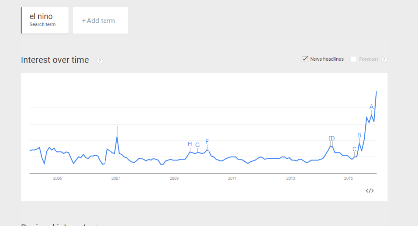
It comes mostly with speculation, preparation, and wonder. Some of the headlines are ridiculous (just go back through photos on my Twitter timeline). Most are reasonable. But it’s news. And it’s clearly a high impact weather phenomenon.

So it begs the question: How’s it doing? Is El Nino behaving like it’s supposed to? Specifically with regard to rainfall. Remember, this El Nino event is a strong one. In fact, it’s the strongest since 1997, and in some respects, it may be the strongest on record. So we have a pretty clear set of analogs to look at and see if this year fits the mold.

Judging by the temperature forecast for the next 10-15 days, the pattern seems to be mostly behaving like a strong El Nino should in December. How about rain? Let’s look back at other actual strong El Nino events and see where 2015-16 is falling relative to those events, specifically in terms of rainfall.

A caveat here: Remember, it’s early. Winter is a marathon, not a sprint. Because something looks one way on December 8th, doesn’t mean one month from now we’re going to be in the same boat. But there are a few interesting nuggets to pull out of this, and I think it’s mostly a good idea to give people some perspective on certain story lines.

Just as a note, my definition for “strong” El Nino events was using a blend from Jan Null’s list post-1950 and Klaus Wolter’s list pre-1950, as well as some “artistic liberty.” Not everyone agrees on the perfect definition of what a strong El Nino is, but hopefully I captured the majority. I’m tracking rain from July 1-June 30.

Southern California

When people think of El Nino, many think of SoCal. You know, mudslides in Malibu, etc. I believe the mayhem of 1997-98 and subsequent personification by Chris Farley has set a level of expectations.

Thus far, 2015 is behaving pretty much about where other strong El Nino events have done in Los Angeles:

Los Angeles Rainfall

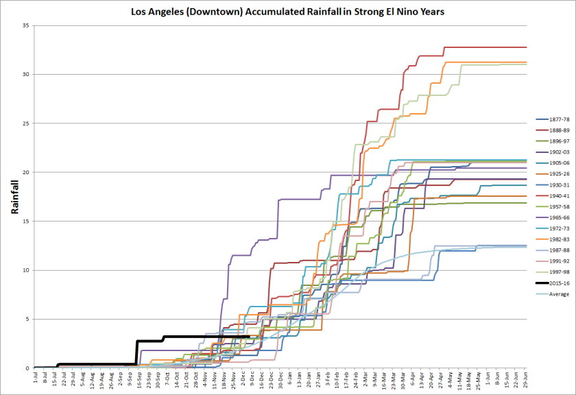
Every strong El Nino event back to the 1800s has had normal or above normal rainfall in Los Angeles. Thus far, thanks mostly to a freak wet event in early autumn, Los Angeles is indeed above normal. It is worth noting, that 2015-16 wouldn’t be the only strong El Nino year to see a “freak” early autumn rainfall event followed by a prolonged period of dryness into December. So if people are wondering where the rain is, wait a few more weeks. We are entering the ramp up period. If things don’t start picking up by late month, then we can start to worry.

Northern California

Northern California is a conundrum during strong El Nino events. Historically, San Francisco is split between above and below normal rainfall, so it’s tough to say too much at this early stage. That said, it is worth nothing, that as of right now, this El Nino is on the lower end of the envelope in terms of rainfall in strong El Nino events in the Bay Area:

San Francisco Rainfall

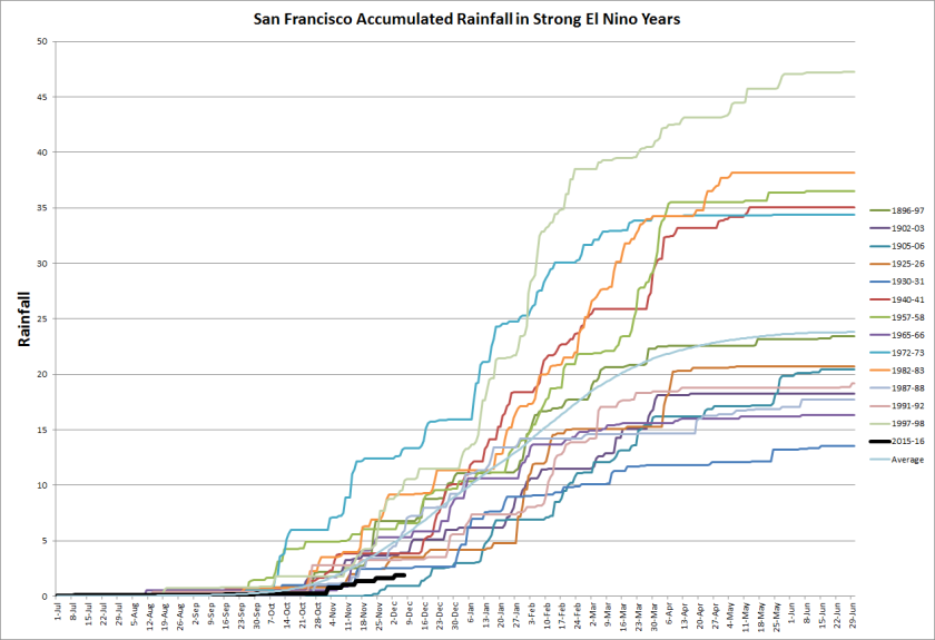
Like Los Angeles, it’s still early. The ramp should start soon if we’re going to go above normal, so again, if things don’t perk up by late December, it might be time to plan on a normal or drier than normal winter at best.

Washington/Oregon

This is where it gets interesting. For the most part, the El Nino signal in the Pacific Northwest is somewhat mixed. You get dry years and you get wet years. Usually, however, you don’t have a super wet year when there’s a strong El Nino.

In Portland (where the data is only available back to the 1957-58 El Nino) no strong El Nino has been wetter than normal. Seattle is mixed from slightly above normal to way below normal. So far in Seattle? It’s the wettest strong El Nino to this point on record, and it’s not even close. This autumn has been incredibly wet so far.

Seattle Rainfall

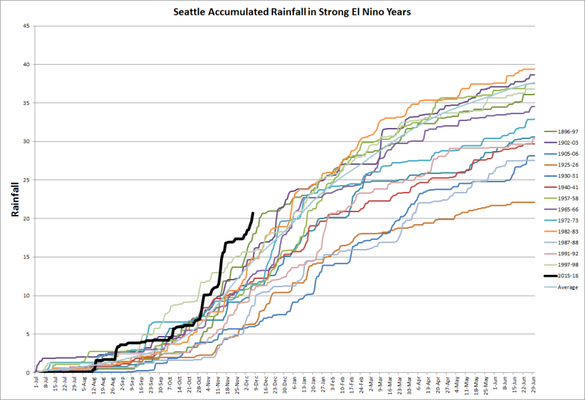
If we keep up at this rate (and the current forecast implies this), this will quickly become one the wettest, if not the wettest strong El Nino event on record in Seattle.
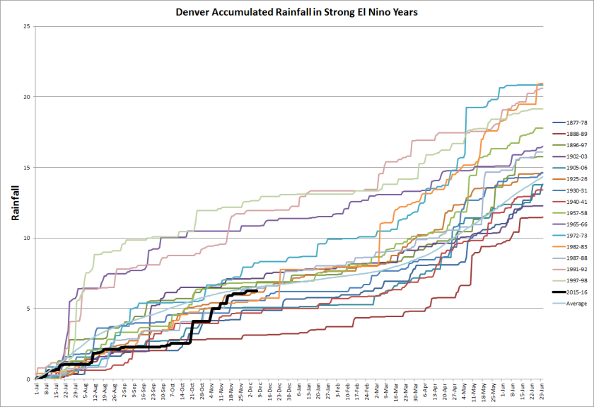
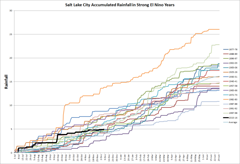
Great Basin/Rockies

In Denver, the bend is toward a wetter than normal outcome in strong El Nino years, but it is mixed. So far, Denver has been mid-pack for strong El Nino events.

Denver Rainfall.png

Salt Lake City is a bit more mixed, split almost evenly between wetter than normal and drier than normal (82-83 was a beast there). So far, we’re doing middle of the pack there also.

SLC Rainfall

It will be interesting to follow this as we go through the cold season. I’ll likely be tracking this, as it’s good to establish where this El Nino event falls. For everyone, it will probably be different. But thankfully we have a useful sample in a number of places to utilize.

The Geographical Statistics of the Red Hot Chili Peppers

Growing up in New Jersey, I would always be particularly pleased whenever a song mentioned the state or a location in the state. There’s a certain amount of pride you feel when a song you hear references where you are. I’ve always had a certain fascination with geography in general, so when you add music, it becomes more fun. On a trip to a conference in Long Beach back in college, I put together a compilation CD of songs that specifically mentioned “the LBC.” 

All that said, today I was listening to the radio, and heard a Red Hot Chili Peppers song (“Dani California”), after hearing another RHCP song in the eye doctor’s office. After coming home and dwelling on it, I realized that the RHCP sure do love them some geography! So I dug in. I reviewed the song lyrics from each song on each album, as well as most compilations/bonus tracks (all song lyrics were compiled via songmeanings.com, so while I can’t guarantee this is a scientific study, it should be “close enough”). What I found wasn’t terribly surprising, but interesting nonetheless.

The ground rules were that to qualify as a geographic mention, it had to reference a specific geographic place or location on the planet. I did not include mention of ethnic groups (Brazilians, Canadians, etc.). If the place name was mentioned multiple times in a single song, it was counted multiple times — except if it was in a chorus verse (repeated in identical fashion more than once). If it was in the song title, but not in the lyrics, it did not count. In most cases, implied references were counted (ie: LA counted as a mention for “Los Angeles”).

By the numbers.

Through their careers, the Red Hot Chili Peppers have produced 10 studio albums and a number of compilations and singles. 

By the rules applied above, I counted 122 individual geographic references in RHCP songs throughout their history.

The most often referenced geographic location? Hollywood, mentioned 21 separate times in their songs. Next most? California, of course, mentioned nine times. 

Interestingly, a mention of “California,” did not appear in a RHCP song until their 1999 album “Californication,” their seventh.

Californication, far and away had the most geographic references of any normal length album, with 27 different ones. Stadium Arcadium had 35 references, but that was spread over two discs (disc one had 22, and disc two had 13).

By the Way had a mere one reference, from the closing song “Venice Queen.”

Some charts. These first two show the breakdown of geographic references tallied from each album. 

Image


Image

How about by place? They’ve mentioned 16 different states, including California. Next most was Michigan at six, followed by Alabama at three. They’ve mentioned eight different US Cities (aside from LA/Hollywood/New Orleans), ten different locations in Europe, and even two bodies of water. Here’s the breakdown of specific mentions:

Image

And the mentions from the “Other” category:

Image

So the next logical question would be: How does their use of geographic references compare to other significant mainstream bands? Something that might be interesting to study. Needless to say, those other bands will have a significant amount of work to do to hit the RHCP threshold.

Complete list of references:

Image

The Missile Launch Edition

An interesting 24 hours here in SoCal. This story about the “missile” is fascinating.  If you haven’t seen the video, here’s the report from a San Diego CBS affiliate (they do a lot of cross-work/outsourcing to their sister station in LA):

So you be the judge. Is that a missile? At first, I was flat sold on it. And to some extent I’m still skeptical it isn’t. What appears to be a rapid movement of whatever it is has me still curious. Time for the obligatory: BUT. But…sunset can do some mighty weird tricks to your eyes. I’ve seen high level clouds at sunset that were at least 100 miles offshore before. And as explained in this blog entry (based on a similar event from several months ago), it’s entirely possible, if not likely, that what was witnessed off the coast of LA was not a missile, but a contrail from a commercial jet. In fact, the author of that blog has pinned down what flight they suspect it was. The government subscribes to that theory…for what it’s worth I suppose. The chopper pilot who caught whatever it was seems to be convinced otherwise. I’m going to cautiously side with the government’s explanation for now. Like I said, weird optical tricks can be played on you at sunset, and the theory about the flight, the timing, and the flight path makes sense. Yesterday was a decent day for contrails as well, so that explanation doesn’t come off as a cop out…it seems rather legitimate. We’ll see what we find out down the line.

Volcano

Damage from Mt. Merapi's Eruption in Indonesia from videographer James Reynolds: http://yfrog.com/0wcnprj

Indonesia continues to be active. Mt. Merapi is so much of an issue right now that President Obama is having to cut short his visit to the country because of concerns about ash from the volcano. Ash and aircraft do not mix at all, so this is probably a prudent move. The image to the left is damage from Merapi as seen by James Reynolds, a videographer of all things natural disaster. Like the volcano in Iceland earlier this year, there is a webcam set up near the mountain. Unfortunately this seems to be very hot and cold, so you may want to bookmark it and periodically check it. According to the Eruptions volcano blog, the estimate is that Merapi has had a VEI (Volcano Explosivity Index) of between 3 and 4 so far. Just to put this in perspective, Mt. Redoubt in Alaska, which erupted in the spring of 2009 was around a VEI3. Our Icelandic volcano this past year (Eyjafjallajökull) was probably similar, if not a little less than Redoubt. So there isn’t anything substantially noteworthy about this from a large scale perspective at this point. For Merapi, this is a pretty typical eruption for it, where historically they’ve had VEI3-4 eruptions.

Lastly, here’s some Associate Press footage of the ash cloud from Merapi. Certainly an impressive scene:

Hitting the Links

Snow fell in Denver finally today, marking the first for them this winter season as well. Those of you snow hounds will enjoy some of the videos in that link, shot by storm chaser Tony Laubach.

A weather enthusiast in Seattle has been analyzing the satisfaction or misery of the summer and winter seasons by doing a statistical analysis. Well, it turns out the summer of 2010 was the 6th worst summer in Seattle since 1948. Summers and autumns in Seattle can be phenomenal, so this is ashame, especially since we’re in a La Nina, which climatologically favors greater than normal precipitation in the Northwest in winter.

Additional work is underway to try and secure New Orleans and surrounding areas from storm surge impacts during a hurricane.

Lastly, a fascinating blog entry…warning: long read about the scientific method and its applications in the current climate science debate. The author is a sociologist of science (awesome title), which basically means he’s studying the philosophy of science. It’s well worth a read (in fact, I am going to re-read it), as the argument about adhering to the principles of the scientific method has been a point of contention, especially since Climategate.