Your East Coast Winter Storm Run-Up Survival Guide

As a forecaster and communicator, I try and approach my audience a lot like I would my mother. Would my mom understand what I’m talking about? Sometimes I deviate and get nerdy; we all do. But when it comes to the forecast details, it has to be simple, clear, and easy to understand.

So my mother sent me an interesting text message today. She said:

Ok. I’m getting anxious. Or curious. I’ve heard so many maybe this or maybe that’s. I want the truth. I’m sick of speculation.

That’s such a great mom text.

In the run up to this major East Coast winter storm, blizzard, Winter Storm Jonas, whatever you use to describe it, you’re going to get a ton of this speculation.

So today, you’re all my mother, and consider this my survival guide for you.

What’s going on here?

The weather models have been hooked on this idea of a major winter storm in the Eastern US for awhile now. There is good agreement among all the various models we use that something is going to happen. Someone’s getting a major storm.

So how much snow am I getting?

No one can answer that question today unfortunately. What we know is that a number of factors are going to contribute to this storm being loaded with moisture. In other words, someone is going to get a *lot* of snow. It’s just not possible to say who that is yet.

Right, right, I get that, but give me your best shot.

This storm is big, slow, and it has a number of complex parts to it that will make it difficult to peg down until we are closer in than usual. But, some trends have evolved in the last couple days that lead us to believe a few facts about this storm.

First, it will be a *big* storm. That means even if you don’t get snow, you may get impacts. It will be slow moving. It will have wind…lots of wind. It will have major, major coastal impacts. Depending on track, we could be looking at a top 5-10 coastal flooding event for folks from the Jersey Shore into Virginia perhaps. That is a serious issue.

But what about snow? The storm has slowly trended south on the weather models. Additionally, it has a very, very sharp gradient on the north side. In plain English? If you live on the northern fringe of this storm, there’s going to be a razor thin margin between major snow and conversational snow.

Here now, a map of where I think things stand as of Tuesday afternoon. Remember, this is subject to change.

011916_snowrisk
My Own Tuesday Evening Snow Synopsis for the Weekend

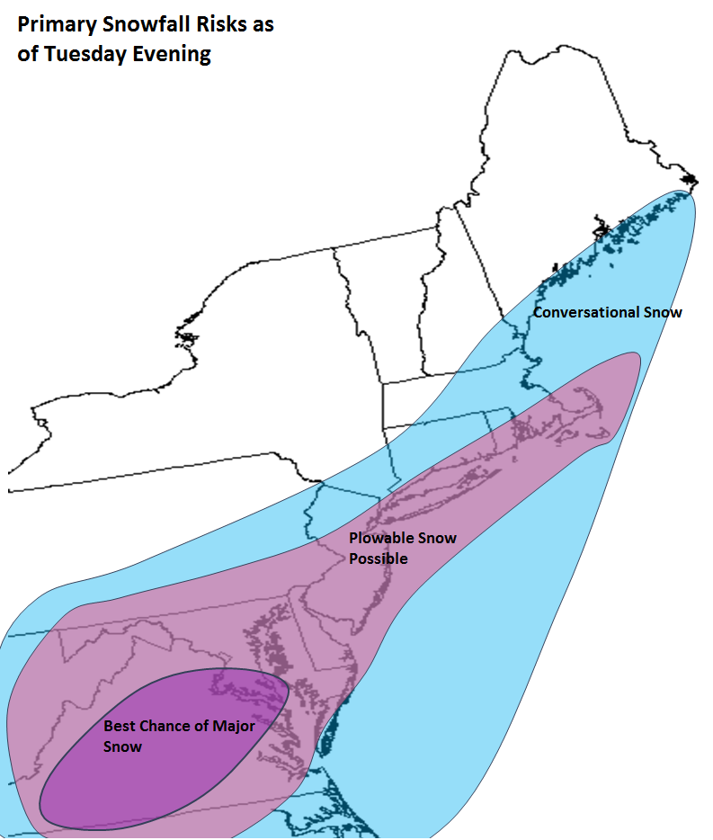
The trouble is in New England, New York City, and Northern NJ. The models show a tremendous cutoff in snowfall here. The next map is a weather model’s output for precipitation (liquid, not snow). I’ve focused on the NYC area.

011916_precip
18z GFS Model Precip for New York City area (Weather Bell)

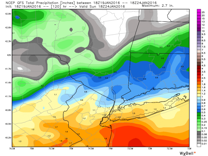
Why am I showing this? Notice how in the Central Jersey area, the model spits out about 1.5″ liquid. Go 50 miles north from there. So, like Orange County, NY? About 0.5″ liquid. A 1″ liquid is roughly equivalent to about 10″ of snow. So 10″ snow difference over 50 miles, and the reality is likely that it will be even sharper than this. You’re talking about (surprise!) a major difference in snow totals likely over a short distance over a major population center.

Bottom line in all this: I have higher confidence in heavy snow hitting Virginia and probably DC right now than I do for the Northern half of NJ, New York, or New England. I don’t focus on North Carolina much since the majority of my family and friends are between DC and Boston. But this has potential to be a big storm in a good chunk of NC also.

Alright, so when does all this unfold?

Snow should start in Virginia as early as later Friday morning, and it probably won’t end until about Saturday night. In Philly, it’s a Friday afternoon start and late Saturday night finish. Add a couple hours to all this as you go north to NYC. I have lower confidence in anything further north, so I won’t speculate beyond this.

What about this coastal flooding?

Yeah, this one goes unchecked sometimes. Snow is way sexier, but this is way more damaging potentially. The NWS office in Mount Holly has done an excellent job highlighting this risk. If you look at storm surge guidance for Cape May, NJ, you’ll see the first high tide cycle impacted late Friday ends up at a water level of about 8.5-8.7 feet. Sandy saw a tide level of 8.9 feet there, October 29, 2011 was 8.7 feet, the December 1992 nor’easter was 8.6 feet. An 8.5 foot tide level would rank in the top 8 all time at Cape May. This one’s big. It’s like a 90’s throwback nor’easter.

011916_Cape May
Cape May Surge Guidance shows a tidal level over 8.5′ Friday night/Saturday AM. This would be a top 10 event without much trouble. (NOAA)

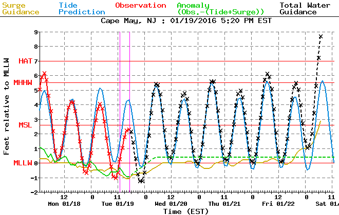
If you live along the coast or Back Bays of New Jersey, Delmarva, Virginia, you should begin planning for the possibility of 2-3 high tide cycles like this. If the storm track shifts a bit or the intensity changes, we could see these values change. It’s a fluid forecast, but it’s a serious issue along the coast. Follow your local NWS office for info and guidance.

So will it be a blizzard?

Maybe for someone. It’s entirely possible, but specific criteria must be met regarding wind speed and visibility. It’s too soon to say exactly where and who or how long, but it’s a distinct possibility.

That’s all for now. Feel free to ask any questions and follow me on Twitter at @mattlanza.

Enter Sandy

Oh hi, blog. I haven’t seen you in about 9 months. Let’s talk about Sandy. Numerous friends/family have asked me questions about this storm already. Hype is in overdrive, but we don’t do hype here.

Sandy is Jamaica’s problem at present, en route to Cuba, the Bahamas, and a brush with coastal South Florida. Not a severe storm relative to what is often experienced in these areas (though it’s interesting to note this is Jamaica’s first landfalling storm since Gilbert in 1988). So where’s it going from here?

ImageWe have two main models we look at (among many others): The GFS and European (Euro). For the last few days the GFS has kicked Sandy out to sea harmlessly, whereas the Euro has blown Sandy up into a monster superstorm, with varying landfall points from New Jersey to New England. The GFS is not a very skillful model with tropical systems in most cases. During Isaac, for several days the GFS suggested the storm would hit the Big Bend of Florida, while the European model went between Pensacola, FL and west of New Orleans. It wasn’t until we got within 48-72 hours of landfall that the GFS showed skill. We’re presently 4-5 days from first impacts with Sandy. That said, even the GFS began to come around today. I pasted an image above of the GFS ensemble members from this morning, which shows multiple ones with a big hit somewhere between NJ and New England.

Now, I do believe the European model is grossly overdoing the intensity of the storm (it missed Irene last summer by about 30 mb of pressure). It’s currently showing 930-940 mb for a central pressure, which is massive. I suspect that comes in reality between 955 and 970 mb. Either way, we’re talking about a big storm.

What does this mean for you?

I am not prepared to make a call on exactly where Sandy will go or how strong it will be or specific impacts, but I will give you some ideas of my thinking:

– Sandy will come ashore later Monday or early Tuesday somewhere between southern NJ and New England.

– Impacts will include strong tropical storm force winds across most of the Northeast and Mid Atlantic, with possible hurricane force gusts on the coast (highest risk of this right now seems to be the New England coast). Whether we get those really strong gusts remains to be seen.

– A full moon will enhance coastal flooding, as a long duration “fetch” over the open ocean could lead to very high tides from NJ north into New England, with west side flooding possible in Delmarva/Hampton Roads.

– Extremely heavy rain will fall, especially inland I believe. The inland flooding threat is difficult to peg down. It may not rival Irene…or it may; it just may occur in a different place. Do not underestimate this angle of the storm.

– Snow will be possible in western Maryland, West Virginia, and Western Pennsylvania as cold air wraps in behind the storm.

What should you do right now? Well, not much. First: Do not panic. Unnecessary….this is not the end of the world. It may just end up like your usual strong nor’easter. That said, it may not be a bad idea to get out in front of this storm and get some hurricane supplies set up before the media hype goes into overdrive (that should occur tomorrow evening). I would advise this for anyone living from NJ into New England, including NYC. Stay tuned to the forecast, and if you have plans Sunday night through Tuesday, start coming up with backup plans you can implement, just in case.

I will be less accessible than usual due to work obligations, so I may not post frequently about this.

April’s Not Foolin’ for New England & Update on Opening Day

Here’s just an updated forecast on Thursday and Friday’s home openers.

Opening Day Thursday

Detroit at NY Yankees
Atlanta at Washington
Still looking at clouds, chilly temps, and scattered showers. I think NY is safe right now, but there are some signs that rain will envelope DC before game’s end, so keep an eye on that.

Milwaukee at Cincinnati
Still looks: Partly cloudy to mostly sunny and generally in the 40s.

LA Angels at Kansas City
San Diego at St. Louis
Still tracking a shower threat in KC. But those look more hit/miss, so I’m not anticipating any major disruption. Saint Louis looks pretty solid with sun and clouds. I’d take mention of showers out.

San Francisco at LA Dodgers
5 PM local time for first pitch at Chavez Ravine, and it will be postcard LA weather. Sunny, with temperatures probably 85-90 for first pitch, slipping into the upper 70s by the end of the game. Second place “Pick of the Weekend.”

Friday’s Home Openers

Minnesota at Toronto
Baltimore at Tampa
Dry and 70s…dome sweet dome.

Houston at Philly
It still looks like the worst of the weather will be in the morning in Philly. The snow/rain will lift into New England during the afternoon. It will be cold, breezy, raw, damp, gross. Should be some flurries around. Despite the fact that the worst will be long gone by game time, I would label this game as a risk to be rained or snowed out though, just because of how miserable the weather will be.

Pittsburgh at Chicago
Mostly cloudy here with some rain showers likely. I doubt it’s delay inducing stuff, but it may make Wrigley an unpleasant experience…sort of a raw, damp day.

Chicago at Cleveland
Still looks partly cloudy here. Looks like low 40s…a pleasant day for baseball, but still a bit chilly.

Boston at Texas
No changes in the ideas here either, except it could be a couple degrees warmer…low to maybe mid 80s in Arlington Friday. The Red Sox will be happy they’re opening there and not in Boston.

Arizona at Colorado
Not what you’d expect in Denver for baseball this early. Sunny, mild, and temps in the low 70s. This is the State of Occlusion “Pick of the Weekend!”

NY Mets at Florida
Taking out any mention of t’storms here. Looks good for the Mets/Fish. Temps upper 70s/low 80s at first pitch.

Seattle at Oakland
Partly cloudy after a nice day when highs should push into the 70s. We’ll see temps around first pitch in the 60s, easing back into the low 60s or upper 50s at game’s end.

Northeast Snow

The map to the left is this morning’s GFS model forecast for snow in the Northeast from Earl Barker’s model website. This is a pretty significant storm, for any time of winter, let alone early April. The GFS forecast is reasonable. Here’s how it breaks down.

NYC-Philly-DC: AM Rain, perhaps ending as some steady snow north and west, with a little coating possible there, and maybe some flurries into the cities.

Northwest NJ/Sussex County: Snow to rain to snow. Ending as a slushy 1-3″ accumulation I think. Higher elevations there could see snow continue longer, and there is definitely a risk that higher snowfall totals occur here. Still model disagreement in this area.

Boston: Mainly a mix in the city, but they could get 3-6″+ just north and west.

Interior CT/MA/Albany: 6-12″ easily, with higher amounts in the higher elevations. Some of those higher terrain areas may see 12-18″ of heavy, wet snow.

Interior NY west of I-87 to I-81 (Albany-Syracuse): Gradually diminishing snowfall gradient of 6-12″ near ALB to 1-3″ near SYR…. 5-10″ for Binghamton/Scranton.

This is just based on a cursory glance, so expect some changes, and refer to the NWS for the most local info. Either way, we’re looking at a large storm, with strong winds possible in New England as well, that could lead to power outages and downed trees/power lines. Just brutal for April.

And find State of Occlusion on Facebook!

Winter Doesn’t Give Up That Easily…

If you’ve lived in the Northeast for any length of time (in years), you know full well that spring almost never comes without a price. Temps in the 60s, 70s, and even 80s over the last week are going to give way to the harsh reality that winter can still rule in March and even April.

Latest plot of recent and forecasted NAO from CPC

To the left you’ll notice a plot of the NAO..the North Atlantic Oscillation. You’ve probably heard of it before, but in layman’s terms, it’s a measure of atmospheric blocking (high pressure) in the vicinity of Greenland. Traditionally in winter, a negative phase of the NAO spells more troughing and thus colder conditions in the Eastern US. You’ll notice from the graph that since the beginning of February, the NAO has been almost locked in a neutral or positive phase. As such, you haven’t seen quite the harsh conditions you all experienced earlier in the winter. But the red lines indicate the forecast, and that, my friends, is what we call a tanking NAO.

Latest Plot of Recent and Forecasted PNA from CPC

Off to the right, you’ll see another, similar chart…this for the PNA, or Pacific-North American Oscillation. This measures blocking near the West Coast. When this is positive, there is traditionally a ridge present out west, which usually can translate to a downstream trough. When you have the NAO in a negative phase and the PNA in a positive phase, that’s a usual rock solid combination to generate warmth out West and cold in the East. It appears, we have these factors ready to lock in for a good 10+ days, with the +PNA holding on a little longer perhaps than the -NAO.

What’s this mean? With them both in concert, it spells strong cold conditions for the Eastern US and a developing warm pattern and end to storminess out West. As the NAO starts to fade, but the PNA stays relatively positive, it means the cold in the East will ease some, but there’s absolutely no sign of a return to the 60s and 70s you’ve seen recently. Expect some 30s, 40s and maybe occasional 50s if you live in the Northeast Corridor through at least next weekend.

How about snow?

A few snow chances exist over the next week or so. I won’t go into many details about the one on Sunday and the one next Wednesday, but suffice to say, the conditions do exist for potential snow.

3/22 12Z GFS Snow Forecast from Earl Barker's Model Site: http://wxcaster.com/regional_snowfall.htm

In the immediate term, we’ve got a situation tomorrow. The map to the left is this morning’s projection of accumulated snowfall from the GFS model. If you live in NYC, you can ignore this for the most part (think the model is a little too aggressive with snow there). This is mainly west of I-287 and north of I-80…but you can clearly see the risk. For Northwest NJ and the Scranton area, despite what this model is showing, I’d be shifting those bands south a bit, and a solid 6-10″ thumping seems likely…very elevation sensitive this time of year, so the higher up you are, the better your odds for snow. The highest amounts seem banded in an area east of I-81, north of I-80, west of I-87, and south of US Route 20. There is some model debate as to how far south the snow will get (one model brings heavy snow as far south as Central NJ). I am going against that model for now due to a poor track record this winter. But you will want to keep an eye on this situation. And if you live in Northwest Jersey/Northeast PA, tomorrow and tomorrow night look very unkind.

Wish I had better news, but enjoy this last gasp of winter if that’s your thing.

Oh, and you can find State of Occlusion on Facebook too!

Facebook Us…Oh, And Snow.

It’s been a disruptive month for State of Occlusion! Transitioning my life offline from the West Coast to the East Coast, so haven’t had time to blog. I’ve discovered Facebook to be an extremely useful tool to communicate short bursts of information and post maps quickly. I will occasionally use this blog to elaborate on various significant events, but in the meantime, for the latest thoughts and information from me, like the Facebook page and tell your friends. We’ve already got 100 fans…let’s go for 200!

Follow State of Occlusion on Facebook for the latest!

In the meantime, while many in the Northeast enjoyed record warmth this Friday, winter is around the corner ready to take its season back. It will be cooler and extremely windy Saturday, followed by a leveling off of temps Sun and Mon. One storm will swing through Monday, potentially dropping heavy snow on Upstate NY, far N PA, into Connecticut and Southern/Central New England. Round two will affect areas south of I-80, somewhere between DC and New York, bringing the potential for very heavy snow on Tuesday as colder, Arctic air pours in. Right now the best odds for this appear to me to be between Baltimore and Allentown, back west across all of PA into Ohio and east into NJ. Potential does exist for 6″ or more with this storm, so this may cause significant travel issues in the Mid-Atlantic on Tuesday. Cold Wednesday followed by another semi-thaw (though not to the extent you saw this week).

I will post updates on Facebook through the holiday weekend.

So About Next Week…

Tonight's 00Z European Model Forecast for Next Wednesday Evening (http://www.meteo.psu.edu/~gadomski)

I’m not one to go bonkers when it comes to any particular storm (in fact, you read me discussing how I would be apt to NOT hype next week a couple days ago). But I think now it’s obvious we have something rather significant showing up here. The three major models tonight all went nuts for the middle of next week, showing an absolutely massive storm slowly rolling up the East Coast. When all three models lock in on a massive storm, that very often means that they’re right. Models struggle and they can be a bit inconsistent at times, but when it comes to the extremely large, widespread or historic sized events, they are usually quick to hit on things. I’m not saying that next week’s storm will be historic, but there’s no question we’re now looking at a significant to major event for much of the Mid-Atlantic and Northeast.

Tonight's 00Z GFS Model Forecast for Next Wednesday Evening (http://www.meteo.psu.edu/~gadomski)

So what are the details? Well, it’s far too early to speculate, but we’ll do just that because we can. Based on tonight’s model runs, we’d be looking at a snow to mix/rain ending as snow event from I-95 to the coast (and even a little further inland from there), with extremely heavy snow/mix possible from the Smokeys north into Upstate NY and interior New England. The storm is also extremely slow moving. For example, the precip begins in Philly on tonight’s Euro run at about Midnight Wednesday and does not end until about 9-11 AM Thursday. Snow moves into the Albany area around 9 AM Wednesday and doesn’t depart until after Noon on Thursday. These aren’t forecasts…they’re just examples of what the model is showing and emphasis on a 24+ hour event.

Tonight's 00Z Canadian Model Forecast for Next Wednesday Evening (http://www.meteo.psu.edu/~gadomski)

The other issue then is track. Tonight’s runs are up along or just inland from the coast. That is extremely unfavorable for heavy snow from DC-Boston…that’s a wet track, not a white one. However, if you look closely at each model’s ensemble mean, you’ll see the track is still fairly far offshore. What does this mean? That the operational models *may* be on the extreme west edge of the track forecast envelope. I wouldn’t go shouting from the rooftops just yet, but it’s something to keep in mind.

We’ve seen a lot of storms the last couple winters, but this one I think is the most impressive looking in terms of physical size and slow track. We’re in a powder keg pattern right now, and this may be the fuse that helps things explode. I’m not going to get into details of the meteorology behind what’s happening right now, but we need to watch things very closely over the next few days. But each model run has looked more impressive with this storm, not less impressive, and that trend may continue as we get closer.

Unfortunately, I’m heading out of town Friday afternoon…well, actually I’m moving, but taking a week or so to drive to Texas, so my updates will be much more infrequent. However, make sure you “like” State of Occlusion on Facebook, as I’ll post updates each night/morning with the latest information. This really could be a big time event, so stay tuned!

Briefly Updating Snow Chances

Just wanted to throw down a brief entry to outline snow chances more specifically.

Snowfall Forecast for the Friday Storm (click to enlarge)

To the left is my first and last call snow map for the Thursday night and Friday “storm.” Again, this will be a quick mover and really not a big system at all. It may get its act together to throw back some briefly heavy snows into New England, and dump mainly a 2-4″ sort of snow back in the red area. Most other areas will only see a coating-2″, with an isolated 3″ amount report or two possible. Timing…arrives in the Philly area after midnight Friday and exits the Boston area Friday after sunset. Quick mover.

Next week’s storm continues to show up on the models today. It does look as though this will be a rather large and strong storm. But the overall track is going to be what is impossible to nail down for several more days. I do expect someone in the interior Northeast to see a decent shot of snow, some areas with potential for a mix, and some areas with a cold, raw rain potentially. I still would avoid hyping this one in the big cities, as it’s far too early to even try and guess how it will unfold specifically. A lot of what does happen is dependent on how a system plowing into the Northwest US this weekend behaves. I’ll be traveling much of the next week, and I’ve been watching forecasts for northern New Mexico fluctuate between sunny and dry to heavy snow for the last several days. Why do you care? Because that shows you the volatility of what that Washington/Oregon storm will be doing…we simply can’t say, and in order to peg down who gets the snow next week in the Northeast, we need to know what will happen out west. So stay tuned.

————-

State of Occlusion is on Facebook! I’m posting some additional cool links and videos, quick model status updates, and snow maps earlier than you’ll get here. All kinds of cool stuff available on our “Like” page. “Like” the blog by clicking here!

What 2 Watch 4

Watching the Onion Sports Dome tonight, so there’s a play on SportsCenter. A couple things to watch. As the annoying snow/ice/sleet/rain storm exits the Northeast tonight, attention focuses on the next two systems. The first one looks to bring a quick hitting shot of snow in a couple days, followed by a much stronger and larger system next week, who’s ultimate fate remains to be seen.

GFS Forecast for Friday Morning, credit: PSU E-Wall (http://www.meteo.psu.edu/~gadomski)

A very quick moving system will swing through the Mid-Atlantic and Northeast Thursday night and exiting Friday afternoon. The map to the left shows the GFS forecast for Friday morning, which has a pocket of moderate to heavy precip in Central Jersey and just south of Long Island. This is a pretty cut and dry situation, with the system sliding through. The only final question is on track. Once that’s in line, we can pin down amounts and locations. Right now it appears that there will be a solid stripe of 2-4″, surrounded by lighter amounts. At this point, the models pin it north of the Mason-Dixon Line and northwest of I-95. So Philly-NYC expect roughly 2-4″ right now. There is the chance it could be closer to 5-6″ in spots, but this will not be a major storm. Then, as the storm blows up exiting the New England coastal region, we could see some heavy snow fly back toward Boston and Eastern Massachusetts. I wouldn’t be shocked to see higher amounts there. Heavy snow will also fall in western Maryland and western PA and parts of WV.

Now heading into next week, the models continue to advertise a significant East Coast event. I’m not entirely convinced this will be a big snow event for anyone in particular. The three main models (Canadian, American, and European) all show the storm. The GFS is a little more suppressed, which isn’t abnormal. So it would just be a mild snow event. The European and Canadian models are much stronger and hug the coast. So what we have here is a situation. We’re a week away and we have a storm showing up, and it could be potentially strong. We’ve got it showing up a little further west than more recent big snow events on the whole. And we have disagreements on overall track.

So, I’ve gotten a lot of questions about next week. The bottom line: Way too far out to hype this thing. It could do any number of things. It could be snow, it could be rain, it could be a mix, it could be nothing. So stay tuned!

————-

State of Occlusion is on Facebook! I’ll post some additional cool links, quick model status updates, and snow maps early on that page. “Like” the blog by clicking here!

Couple Things to Watch

Been a quiet few days after the New England Blizzard. I’m also in a transitional phase of life, moving from California to the East Coast starting next weekend. So apologies for that, though there hasn’t been much to talk about either. But let’s focus on a couple things. We have a couple main stories to discuss: A mixed precip event this week, followed by more cold, and then the potential for another major East Coast storm. Let’s look them over.

Messy Mix

The map to the left (click to enlarge) shows the precipitation type being forecast by the NAM model for Tuesday (credit Wxcaster.com: http://wxcaster.com/regional_snowfall.htm). The green is rain, purple/pink is sleet, red is freezing rain/ice, and blue is snow. Notice that as the precipitation moves in and through, especially across the higher terrain north and west of the Big Cities, it starts as an icy mix, before warmer air begins to gradually flood in, changing the mix to rain. The GFS shows a similar scenario, but with more precipitation. Total amounts range from about 1/3″ to 1/2″ liquid on average. So this won’t be a crippling storm, but there could be some localized nasty travel Tuesday and Tuesday night, especially in interior NW Connecticut, parts of NY State (especially south of Albany and north of the NJ border), and possible interior western Massachusetts. Some of the valleys further east in New England could also lock in the cold air at the ground a little longer and may see some localized issues. This looks more like an advisory level event rather than a warning level event. But keep it in mind if you’re traveling Tuesday or Tuesday night.

It will then stay rather cold heading through next weekend. The models seem to have backed off in the last couple days on how serious the cold will be, but it still looks relatively cold for the time being.

European model forecast for next weekend: Credit - http://raleighwx.americanwx.com

Then we have to watch the next area of concern. The map to your right is a forecast from this morning of the European model for next weekend. Yes, that’s a 976 mb low just east of Boston. The GFS model shows a lot of energy, but not quite the major storm scenario…for now. Both models have been showing some sort of storm possible in the Northeast around this timeframe for several runs now. What has to be watched is energy moving into the Western US later this week, likely bringing a quick bout of snow to the Intermountain Region and Rockies. As that progresses east, we’ll see if the pattern still looks ripe for storminess…but there’s a lot of energy around in the atmosphere starting late week or early weekend. This may be what is needed to generate the next round of excitement in the Northeast. Stay tuned.

————-

State of Occlusion is on Facebook! I’ll post some additional cool links, quick model status updates, and snow maps early on that page. “Like” the blog by clicking here!

More Wintry Mayhem

This might be the worst period of travel of all the storms we’ve seen the last two winters. With 1,000 flights cancelled in Atlanta tomorrow, and the odds increasing that this southern storm is going to become a major Northeast snowstorm, airline schedules are going to be absolutely logjammed this week. This is looking ugly right now. Travel in the Deep South is becoming difficult if not impossible in spots. A stripe of 3-6″+ of snow, plus a stripe of 1/4-1/2″ ice accretion, and you have issues.

Snowfall Outlook for the Midweek Storm (Not a forecast)

My snowfall outlook for the Northeast is at the left. We’re still a solid 48 hours away from things beginning. But this is just meant to give you an idea of the highest probabilities of the highest snow. This is not meant to be a forecast and should not be treated like one. To sum up the models this morning: All models take the low and develop off the Northeast coast. Some are closer than others (NAM/Euro) and bring heavier precip. There’s going to be (again) a sharp cutoff of the western extent of the real heavy snow, vs. generic 3-7″ totals. There will also be a sharp southwestern cutoff to this as well.

So what does this mean? It means that in specifically New Jersey I think, there’s going to be a very sharp gradient that cuts off somewhere between Atlantic City, Trenton, and about Parsippany. North and east of that line, odds for heavy snow (6-12+) increases significantly. South and west of it, the odds drop off. It will be a little while before we can really peg that down. So for now, roughly from about NYC into New England stands the highest odds for significant snow. There is a strong possibility of a 12-18″ area of major snows, somewhere between the immediate north and east side of NYC into Southern New England. Mixing may cut down some totals in Eastern Long Island and coastal S New England, but for now, I just carpet bombed the whole area for potentially significant snows until we can know more. The DC and Baltimore areas, as has been the case most of this winter, look to get shafted by this storm, caught in between the developing coastal and dying inland low. I think this means 1-3″ at most, but we’ll see. Philly is on the cusp between the heavy stuff and nuisance stuff, so think 4-8/5-10 type snows for now.

Can things change? Yes. The NAM and Euro models are the beefiest right now in terms of heavy snow. In my opinion, they’ve had some strengths this winter, so I’m leaning more heavily on them together. The GFS model is a little too far offshore in my opinion, and thus produces lighter snow. The short range ensembles are also not very excited about this storm, but they also underestimated snow in the last event, so I would take them with a grain of salt.

So stay tuned, as there will be tweaks and changes, but I feel personally that this will be a nuisance event in DC/BWI, moderate event for Philly and South Jersey (potentially significant for the Shore), a significant to borderline major event for NYC, and a major event for much of interior Southern New England (some shadowing may occur in some areas, so it may not hammer ALL of SNE, but it looks promising to be good for many).

————-

Just a reminder… State of Occlusion is on Facebook. I’ve posted some additional cool links, quick model updates, and snow maps early on that page. “Like” the blog by clicking here!