Blizzard 2016 Thoughts

While it is still fresh, some thoughts on this storm.

1.) Give New Jersey the record it deserves. Being a native of New Jersey, I sincerely hope NWS investigates the 33″ Morris Plains and 35″ CoCoRaHS ob from Mine Hill. The 24 hour record for snow in Jersey was 32″ in 1915 in Rutherford. Based on the timing of snow obs at Morristown (MMU) and Somerville (SMQ), I suspect almost all this snow fell within a 24 hour period, and if the totals can be vetted and verified, a new state record should be established.

2.) Kudos to forecasters and communicators. While this was a challenging storm to pin down, I thought almost *all* forecasts for this event were incredibly well done. Everyone deserves credit. Unless you bought the NAM literally and took 1-2′ of snow to I-90 in Massachusetts, or unless you completely ruled out any chance of New York City seeing major snows, you did well in this event.

Between the uncertainty of the northern fringe gradient, the potential for epic snows around DC, the coastal flooding potential, there was a lot to communicate in this event. In my opinion, it was all done very effectively by so many within the weather community, from the NWS, TV, private sector, and social media types.

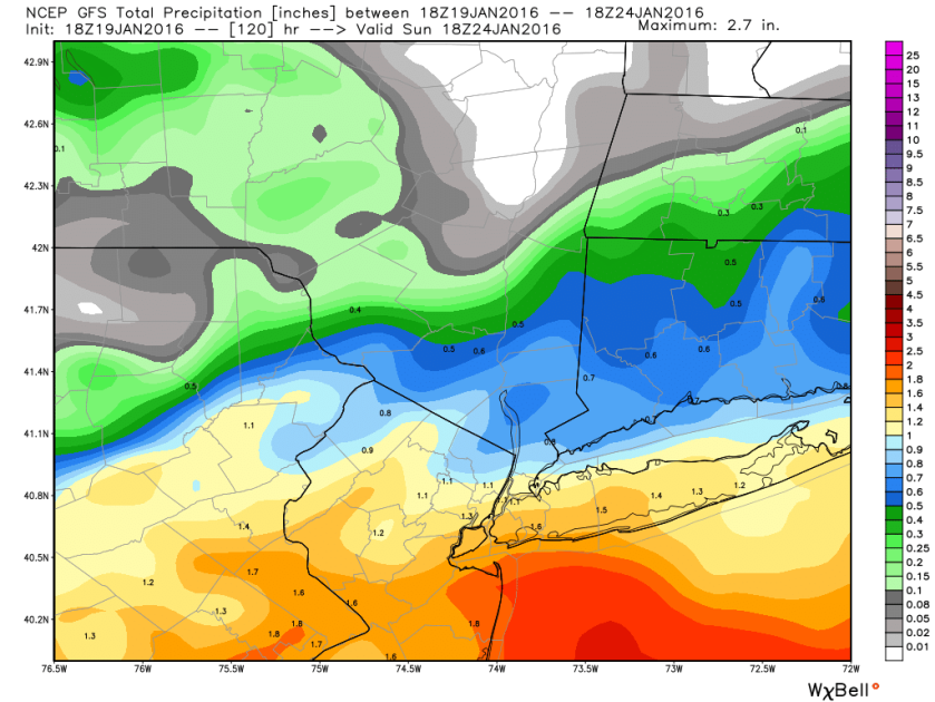
3.) It’s not the model, it’s how you use it. The amount of “modelology” surrounding this event was…annoying to say the least. So many people declaring the NAM victorious. At one point or another, most major global models indicated enough variability and risk on the northern fringe of the snow to include most of New Jersey and New York City within the “margin of error” so to speak. The NAM did not “win.” Again, judging by the map above, if you lived in Hartford or Springfield, MA or Boston and used the NAM, you had a lot of egg on your face. That’s not an inconsequential populous. Yes, the NAM was the more aggressive model in New York City and on that metric alone, it did well. But it didn’t win. No model “wins.” As a forecaster, it’s your job to objectively analyze the models…all of them…use every tool in your toolbox and make a call. If you blended the NAM with the RGEM and the Euro/GFS, well then you did *damn* good in this event with your snow forecast most likely. Likewise, if you outright dismissed the NAM because of last winter’s NYC debacle, you probably failed too. Recency bias will kill you. Many of us joked about the NAM being the NAM…and that is certainly exaggerated by some of us (including me…I do use the NAM daily when forecasting for Texas and Louisiana, and I have used it aggressively at times). It has a reputation for being sketchy, but I know most rational forecasters do use it and consider it.

We just can’t turn this into some training camp competition. If you use the NAM alone for the next event, I guarantee you your forecast will have serious shortcomings. Use all the tools; know their strengths and weaknesses in the areas you care about and leverage them to your advantage as a forecaster. And don’t fall prey to recency bias.

4.) Can we please figure out snow measurement? This is not a uniquely DC thing. It’s been a problem in New York City in the past. It’s a problem in Denver. It’s a problem in so many places.

Fully understanding weather and changes in climate in places is heavily dependent on having a long set of reliable actual measured data at those places. When we can’t depend on data being reliable, what use do we have for it? Why do we have a top 10 list of snowstorms? Why even bother? It’s time for someone to step in, standardize, and properly coordinate snow measurements at places. Cost isn’t an issue. The way I’d approach it: You know how many people would volunteer to do it correctly and love every second of it? Find a spot representative of a city (not an airport across from it and adjacent to a river), probably on state or federal property, and have a team of volunteers at the ready, able to coordinate, trained properly by NWS, and eager to jump in when snow is predicted. Adjust the site as needed for changes in population distribution, new construction, etc. We’re making this a lot more difficult than it needs to be.

5.) Storm names are fine, but we don’t need 30 of them. When they started, I was skeptical of The Weather Channel naming storms, though I believed from the beginning that it would be a successful venture. I think to this point, the storm name concept has worked. I get the frustration, but that ship has sailed and it’s not coming back. So we either do it right or we continue doing it this way, where there were at least 6-7 different storm name hashtags for the same storm. It’s a patchwork free-for-all, and it would be nice if we could streamline it. It would be better for everyone. The research argument is simple: How on earth can we find pictures and tweets from this event without searching through eleventy different hashtags? Instead of still griping about the fact that it’s done, come up with a way to do it better and get everyone to agree. It will be less difficult than anyone thinks, but to make it universal, it can only come from the NWS. It’s time.

Those are my thoughts. What are yours?

Follow me on Twitter: @mattlanza.

Jonas 2016: ♫ People Are Blowing Snow ♫

If you haven’t thought of the Weezer song with regard to this storm, you’ve failed me. It deserves some parody. I tried. Oh well. Onward…

What’s changed since yesterday, Matt?

Not much. Other than bread and milk supplies in the grocery store being dwindled.

  • The storm is still coming.
  • It still appears the metro Washington, DC area is the bullseye for snow.
  • Coastal flooding is still a serious concern.
  • Blizzard Watches have been expanded to include much of Jersey, Philly, and the New York City area and Blizzard Warnings are posted for DC and Baltimore.
  • The northern edge of the storm is still going to drive most meteorologists to their local bar.

So how much snow for me?

Here’s my updated map:

012116_Snow_Forecast
My own personal snow forecast as of 5:30 PM ET Thursday. Again, not official, but my way of expressing it.

Again, I’ve highlighted the two key areas of uncertainty. The northern fringe is going to be a royal pain. There are some models that still bring good snow 8-12″ to NYC, but I don’t personally buy that scenario right now. Based on my experience, these sorts of storms have disappointed on the northern fringe, so I’d rather take a conservative stance there.

From Philly into Baltimore and DC, it gets complicated too. You’ll have a number of factors driving snow totals. I expect there to be issues with mixing in spots. Convection (thunderstorms…yes, thundersnow) will also be likely with this storm. In those cases, sometimes strong bands of snow setup over one place and effectively “rob” another of snowfall. So it’s possible that the final snow totals will not look this uniform. You could easily go from 18″ one place, to 10-12″ a couple towns over, back to 18″ a couple towns over from that. It’s chaotic. Snow forecasts aren’t meant to be simple.

What about the blizzard part?

Yes, Blizzard Watches and Warnings are posted all over. Fun fact: The amount of snow you see has 0 factor in whether or not a storm is defined as a blizzard. Why is that? My honest answer is because we like to make things difficult on ourselves as forecasters and communicators. That aside, it has to do with impacts mostly. A blizzard is supposed to mean wind, which limits how many storms meet the criteria of one…thus making it special and making it stand out.

For a storm to be a blizzard, it has to have 3 hours of winds sustained at or frequently gusting to 35 mph and visibility below 1/4 mile. That’s all. So we’ll see if that gets achieved, but based on model data, yes, it looks like blizzard criteria will be met at many places. For the sake of yourself, stay home Saturday.

How about the coastal flooding?

Here are the very latest tidal forecasts for Cape May, Atlantic City, and Sandy Hook. You can select others from those sites.

I heard this was going to be like Sandy?

Here’s something that agitated me today. I heard from several people somewhat panicked, thinking this was going to be Sandy II. Sandy was a 940 mb monster storm to the south of NJ, that was dragging days of water across the Atlantic Ocean directly into Jersey and New York. This storm will be strong, but it will be moving away from the coast. It won’t have nearly the same characteristics as Sandy did. Meteorologically, it’s like comparing apples to oranges.

But in terms of actual impact what does it mean? It means something worse than what you saw back in October with Joaquin, but short of what you saw in Sandy. It means a lot of water, yes, and major coastal flooding and a top 10 event perhaps. It means problems. The coast is more vulnerable now than it was 5 years ago.

That said, it does not mean mass devastation like was seen in Sandy. So you are right to be preparing and be concerned. But should you panic? No. Make your preparations as you would for any major coastal storm. Remain calm and heed the forecasts of the National Weather Service.

This will likely be my final forecast post on this storm. Thanks for reading and hope you have some time to enjoy the power of nature without being impacted too hard.

Follow me on Twitter @mattlanza.

Jonas 2016: Make Snow Forecasting Great Again

I don’t have any mom texts to run with today, but I do have a map. We’ll get to that shortly. Let’s break things down.

So what’s changed since yesterday, Matt?

Honestly? Not much really. We still have a storm. It’s still early in the game for snow forecast maps, but we can at least make some assumptions. We still have a major coastal flooding issue to deal with. We do have blizzard watches posted, among other NWS watches and warnings. All this means is “prepare for a snowstorm.”

Where are the watches and warnings?

Glad you asked. Here:

012016_snowwarnings
National Weather Service Watch/Warning Map as of 5:45 ET Wednesday

In the East, the purple are winter weather advisories, the blue winter storm watches, the pink winter storm warnings, and the green near DC is a Blizzard Watch. Consult your local NWS office website for what it all means exactly, but the bottom line is a major winter storm is going impact places from Central Arkansas to New York City.

Has the coastal flooding idea changed?

Not really. There have been some forecast tweaks, but overall you’re still looking at a top 5-10 coastal flooding event along the Jersey and Delaware Shore, and possibly for places south and north of there also. Basically, this should be the worst you’ve seen since Sandy. It should *not* match Sandy in most places (though in Cape May and Delaware it’s going to come close), but I don’t want that to diminish the significance. The coast is far more vulnerable in spots now than it was then, so just because it’s not Sandy II, does not mean it’s going to bust. This is a big deal. Here are the very latest tidal forecasts for Cape May, Atlantic City, and Sandy Hook.

This flooding event will rival some of the great nor’easters in memory. Think Ash Wednesday 1962, Halloween 1991, December 1992. This storm will have elements of those storms and it should be treated seriously if you live on the coast or back bays.

Alright, so talk to me about snow.

Here is *my* snow forecast thinking. This is not an official forecast. It’s subject to change, and you should always consult the official NWS forecast or local TV for the most up to date info. Yes, I’m a native of Jersey and spent 5 winters drawing snow maps in Upstate New York when I worked in Syracuse and Utica, but I live in Texas now. I can only do so much.

012016_Snow_Forecast
My snow forecast as of Wednesday evening. Not an official forecast, just my own opinion.

What do I think? Some key points.

The northern fringe of this storm is an absolute nightmare. If you live north of I-195 in NJ or I-76 in PA, this is going to be an incredibly difficult forecast to peg down. The tight gradient in snowfall that I spoke of yesterday is going to wreak havoc. A 20 mile shift in track of the storm (highly possible) could lead to a 6-12″ difference in snow totals, if not more. This is going to be a big problem for North Jersey, possibly the Harrisburg metro area, New York City and extreme southern Connecticut/Long Island.

The Jersey Shore is oscillating between a total mix scenario and a thumping snow. I don’t think this is like the storms of 2009 and 2010, where coastal South Jersey absolutely raked in snow totals. This will be more complex, and I’ve cautiously gone about 3-6″ there, but I do see risk for higher amounts depending on the exact final track.

The thump zone for this will be Northern/Western Virginia through DC and Baltimore. While I don’t expect a uniform 18-24″ in that zone, I do expect some locations to push 30″, contingent on mixing and thunderstorm potential. Other areas will see less than 18″. That’s the nature of snowstorms like this.

Yes, thunder is going to be likely from VA through NJ with this I think.

Winds of 30-50 mph are likely, and some gusts could be even stronger. This will create blizzard conditions. I would not be shocked to see Blizzard Watches expanded tomorrow.

Anything else I should know?

Snowstorms are fun. This one is going to be big, massive, and historic. While fun, it has a very serious element to it that should be respected. If you have plans on Saturday, I would strongly consider rescheduling them. Heed the warnings from NWS. They’re not just throwing this stuff out there. It’s serious.

And please consider taking pictures of something other than your patio furniture. Seriously. Get creative!

Follow me on Twitter @mattlanza.

Your East Coast Winter Storm Run-Up Survival Guide

As a forecaster and communicator, I try and approach my audience a lot like I would my mother. Would my mom understand what I’m talking about? Sometimes I deviate and get nerdy; we all do. But when it comes to the forecast details, it has to be simple, clear, and easy to understand.

So my mother sent me an interesting text message today. She said:

Ok. I’m getting anxious. Or curious. I’ve heard so many maybe this or maybe that’s. I want the truth. I’m sick of speculation.

That’s such a great mom text.

In the run up to this major East Coast winter storm, blizzard, Winter Storm Jonas, whatever you use to describe it, you’re going to get a ton of this speculation.

So today, you’re all my mother, and consider this my survival guide for you.

What’s going on here?

The weather models have been hooked on this idea of a major winter storm in the Eastern US for awhile now. There is good agreement among all the various models we use that something is going to happen. Someone’s getting a major storm.

So how much snow am I getting?

No one can answer that question today unfortunately. What we know is that a number of factors are going to contribute to this storm being loaded with moisture. In other words, someone is going to get a *lot* of snow. It’s just not possible to say who that is yet.

Right, right, I get that, but give me your best shot.

This storm is big, slow, and it has a number of complex parts to it that will make it difficult to peg down until we are closer in than usual. But, some trends have evolved in the last couple days that lead us to believe a few facts about this storm.

First, it will be a *big* storm. That means even if you don’t get snow, you may get impacts. It will be slow moving. It will have wind…lots of wind. It will have major, major coastal impacts. Depending on track, we could be looking at a top 5-10 coastal flooding event for folks from the Jersey Shore into Virginia perhaps. That is a serious issue.

But what about snow? The storm has slowly trended south on the weather models. Additionally, it has a very, very sharp gradient on the north side. In plain English? If you live on the northern fringe of this storm, there’s going to be a razor thin margin between major snow and conversational snow.

Here now, a map of where I think things stand as of Tuesday afternoon. Remember, this is subject to change.

011916_snowrisk
My Own Tuesday Evening Snow Synopsis for the Weekend

The trouble is in New England, New York City, and Northern NJ. The models show a tremendous cutoff in snowfall here. The next map is a weather model’s output for precipitation (liquid, not snow). I’ve focused on the NYC area.

011916_precip
18z GFS Model Precip for New York City area (Weather Bell)

Why am I showing this? Notice how in the Central Jersey area, the model spits out about 1.5″ liquid. Go 50 miles north from there. So, like Orange County, NY? About 0.5″ liquid. A 1″ liquid is roughly equivalent to about 10″ of snow. So 10″ snow difference over 50 miles, and the reality is likely that it will be even sharper than this. You’re talking about (surprise!) a major difference in snow totals likely over a short distance over a major population center.

Bottom line in all this: I have higher confidence in heavy snow hitting Virginia and probably DC right now than I do for the Northern half of NJ, New York, or New England. I don’t focus on North Carolina much since the majority of my family and friends are between DC and Boston. But this has potential to be a big storm in a good chunk of NC also.

Alright, so when does all this unfold?

Snow should start in Virginia as early as later Friday morning, and it probably won’t end until about Saturday night. In Philly, it’s a Friday afternoon start and late Saturday night finish. Add a couple hours to all this as you go north to NYC. I have lower confidence in anything further north, so I won’t speculate beyond this.

What about this coastal flooding?

Yeah, this one goes unchecked sometimes. Snow is way sexier, but this is way more damaging potentially. The NWS office in Mount Holly has done an excellent job highlighting this risk. If you look at storm surge guidance for Cape May, NJ, you’ll see the first high tide cycle impacted late Friday ends up at a water level of about 8.5-8.7 feet. Sandy saw a tide level of 8.9 feet there, October 29, 2011 was 8.7 feet, the December 1992 nor’easter was 8.6 feet. An 8.5 foot tide level would rank in the top 8 all time at Cape May. This one’s big. It’s like a 90’s throwback nor’easter.

011916_Cape May
Cape May Surge Guidance shows a tidal level over 8.5′ Friday night/Saturday AM. This would be a top 10 event without much trouble. (NOAA)

If you live along the coast or Back Bays of New Jersey, Delmarva, Virginia, you should begin planning for the possibility of 2-3 high tide cycles like this. If the storm track shifts a bit or the intensity changes, we could see these values change. It’s a fluid forecast, but it’s a serious issue along the coast. Follow your local NWS office for info and guidance.

So will it be a blizzard?

Maybe for someone. It’s entirely possible, but specific criteria must be met regarding wind speed and visibility. It’s too soon to say exactly where and who or how long, but it’s a distinct possibility.

That’s all for now. Feel free to ask any questions and follow me on Twitter at @mattlanza.

One Does Not Simply Pull a Weather Forecast From Thin Air

This post is admittedly a rant post. I’m not going to drop knowledge on you. I’m not going to come to a groundbreaking conclusion. But I am going to offer an opinionated rant.

What will the weather be for Super Bowl XLVIII?

No one: Not the NFL, not the world’s greatest meteorologist, not the Farmers Almanac, not AccuWeather’s 45 day forecast, not me, not you knows what the weather is going to be on February 2, 2014 at about 6:25 PM EST. No one knows…no one has a clue…you could make a forecast as good as me, well versed in long-range forecasting with 10 years of experience under my belt. In fact, I’ll bet you can probably beat me to make a forecast that specific in place and time.

Yet, we’re devoting an absolutely absurd amount of time discussing it, analyzing it, breaking it down, harping over contingency plans. 

Besides filling time on NFL themed shows, what is this accomplishing? Anything? Could someone please show me how any of this has been helpful to anyone, ‘cuz if ya’ can, I’ll give you a lot of credit.

I’m ranting. I’m annoyed after seeing this article from nj.com:

Super Bowl weather: NJ climatologist ripped for ‘one of the dumbest weather predictions’ in history

Peter King, a well regarded NFL columnist, shredded Dr. David Robinson, one of the best climatologists in the field, for Robinson’s comments on “That Other Pregame Show” on Sunday. If you sit through the 5+ minute clip (and it is a good watch), and then read King’s comments, you might ask yourself, “Huh?”

Thankfully, Robinson shot back at King today. 

That should put the matter to rest, but it highlights an unfortunate problem inherent to the field of meteorology. To liken this to a football game, since that’s what all the hubub is about: Despite all of the advancements in and lives saved thanks to weather prediction, meteorologists are constantly running a 2 minute drill, down three touchdowns, starting inside their own five yard line. Why? Because the perception is that we’re going to get it wrong when it matters most to someone: Not when their lives are in danger, not when a hurricane or tornado is coming at them. No, none of that…it’s when it truly matters most to people: An outdoor birthday party, a trip to the beach, a football game in February. 

So when someone like King, who has a megaphone and a lot more reach than some of us have, says a forecast made by a climatologist is “one of the dumbest weather predictions in meteorological history,” it deepens this hole that meteorologists have to dig themselves out of. On top of all that, he clearly had a preconceived notion (“I want to take a swipe at weather forecasters because they’re easy targets”) and only listened for what he wanted to hear from Robinson. If you watch the clip, Robinson never makes an actual forecast. He answers a question. He’s providing a past history of the weather on and around that date, and he answers the question asked of him. There’s no forecast here…no agenda, except for that of a frustrated football writer who wants to use up space dissecting the weather forecast for the Super Bowl, a month and a half before it kicks off.

When the perception is that you’re going to fail, how does one get over that hump and above the noise to shut someone like this up? How many Sandys, Katrinas, or lives saved thanks to advanced tornado warnings is it going to take to finally rid meteorologists of this unfair reputation of “being right half the time and keeping our jobs?”

There’s no right answer…but it further illustrates how those of us in the meteorological community need to continue to run that 2-minute drill and make sure the message we’re communicating doesn’t get lost in the noise. It’s not an easy task, but it surely presents an opportunity to improve ourselves and stand out.

Historic Early Season Snowstorm

Snowfall forecast for Saturday - click to enlarge!

Sometimes, you just need to call it what it is. This is straight up a bonafide snowstorm, the likes of which not many people have ever seen or probably will ever see again…because of when it’s occurring. If you showed me these maps, I probably would have guessed mid to late November…still early, but more reasonable. If this storm occurred in December, we’d be talking about a blizzard for the Northeast Corridor. It’s remarkable by every stretch of the imagination.

The snow map is above, and here are a few things to note…especially the 3rd one…

1.) Wind: It will be strong, with our models today suggesting we see some 20-30 mph winds in the interior, with perhaps some 40-50 mph gusts on the coast. This will cause havoc inland, as any sort of wind > 10 mph with heavy, wet snow on trees that still have some leaves will lead to trees coming down and likely widespread power outages in the red area, numerous power outages in the purple area, and scattered outages in the dark blue area.

2.) The Northwest Connecticut into Western/Central Massachusetts corridor looks to be absolutely crushed by this storm. It will likely be an extremely severe hit there and could be one of the worst snowstorms in terms of problems and inconvenience for them in recent memory.

3.) Elevation will play a MAJOR role in this storm. While I have opted to unfilter things a bit regarding snow amounts, I can’t help but feel that there may be a wide and sometimes unbelievable disparity in snow totals in some areas…especially in and around Hartford, CT, Morris County, NJ, the area between Reading and Pottstown in PA, north and west of Baltimore…all places where terrain tends to transition from the more flat Coastal Plain to the Appalachian foothills…this may occur elsewhere as well, especially in valleys, like the Lehigh, Susquehanna, and Connecticut Valleys. You may see some areas with 2-3″ of wet snow…travel 5 miles north to slightly higher terrain and see 6-10″ of snow. It will be that kind of storm…the kind where a truly accurate snowfall forecast map is next to impossible.

4.) The Big Cities will likely see flakes…especially Philly-Boston, but mostly at the tail end of the storm and any accumulation should be minor and mostly on grassy surfaces….though Saturday evening could be comical in some places.

So go load up on supplies for Sunday’s football games, enjoy game 7 tonight, and enjoy the snow while you have it, because warmer air will start melting this stuff as fast as Sunday afternoon.

Yes, It Does Snow in October

Snowfall Forecast for Saturday, 10/29 Storm. Click to enlarge!

It has happened before, and it will happen again. Snow in October I mean. This will probably be somewhat overhyped, given that it is October, but still…this is a very, very impressive storm for this time of year. And given that it’s coming on the heels of a storm that’s currently producing snow in parts of Upstate NY and New England, it makes it somewhat more impressive. So with that said, the computer models we look at have come into much better agreement today with a coastal low developing Saturday and bringing absolutely miserable weather to the Northeast and Mid-Atlantic. College games may be more entertaining than usual, with Illinois at Penn State and West Virginia at Rutgers (which has seen snow and/or cold rain occur on several of their past meetings…some of which have occurred in December, not October…so blame the NCAA I guess for this).

Anyway, for most of the Big Cities, this will be a cold, miserable rain. Temps starting the day in the upper 30s or lower 40s will fall into the mid 30s….with rain. At times when the rain is heaviest, there may be some wet snowflakes coming down, but accumulation should be nil. Philly and Baltimore could run the risk of a coating in a few grassy spots. But nothing more than that I don’t think.

That’s the higher confidence part of the forecast. It gets lower as you get outside the cities. This is very sensitive to the final track of the storm. We have one shorter term model that insists this thing is going out to sea and being a waste. Fortunately, it’s one of our most unreliable models, so I’m not putting much stock into that right now. The GFS and Euro models…the two bigger boys…are both suggesting a coastal low and producing some rather impressive snow amounts at rather low elevations. There is some risk that the immediate N & W suburbs of NYC and Philly do better in this storm than we might think. This is very out of season obviously, so my gut is to use slightly more rigorous thresholds for snow to accumulate (especially given that you’ve had nary a freeze this year thus far in most areas). But the further north and west you go, the better you should do. I’m up to 3″ at most right now, but there is some potential if the air mass is a little colder or the storm a little further west that these amounts could be a bit higher.

The main area of concern is the northern Lehigh Valley into the Poconos and Northwest Jersey, then into the Catskills and Berkshires, as well as parts of northern Connecticut and central Massachusetts. Provided the storm track stays near where it is now, I think 3-6″ is likely in these areas, with higher amounts a very good possibility as you go up in elevation. This sort of snow is somewhat unimpressive, but given it’s October and many trees are still leafed, a little bit of gusty wind could cause a lot of problems with a very heavy, wet snow coating trees/power lines. So this is why this storm is somewhat of a concern and of interest.

A couple things to keep in the back of your mind: It’s October and it is not easy to accumulate snow this time of year. There are many factors working against it. But this may be the rare instance where it works really well. Secondly, the final storm track will obviously be what determines who gets what. The models have been…for lack of a better word…awful the last few weeks. So there is some risk that they may be flat out wrong. But, given past experience, typical biases, and recent trends, this is where we stand 48 hours before it occurs.

So stay tuned…I may not draw up another snow map for this event, but this is a good jumping off point. Enjoy this first taste of winter!

On Facebook!

April’s Not Foolin’ for New England & Update on Opening Day

Here’s just an updated forecast on Thursday and Friday’s home openers.

Opening Day Thursday

Detroit at NY Yankees
Atlanta at Washington
Still looking at clouds, chilly temps, and scattered showers. I think NY is safe right now, but there are some signs that rain will envelope DC before game’s end, so keep an eye on that.

Milwaukee at Cincinnati
Still looks: Partly cloudy to mostly sunny and generally in the 40s.

LA Angels at Kansas City
San Diego at St. Louis
Still tracking a shower threat in KC. But those look more hit/miss, so I’m not anticipating any major disruption. Saint Louis looks pretty solid with sun and clouds. I’d take mention of showers out.

San Francisco at LA Dodgers
5 PM local time for first pitch at Chavez Ravine, and it will be postcard LA weather. Sunny, with temperatures probably 85-90 for first pitch, slipping into the upper 70s by the end of the game. Second place “Pick of the Weekend.”

Friday’s Home Openers

Minnesota at Toronto
Baltimore at Tampa
Dry and 70s…dome sweet dome.

Houston at Philly
It still looks like the worst of the weather will be in the morning in Philly. The snow/rain will lift into New England during the afternoon. It will be cold, breezy, raw, damp, gross. Should be some flurries around. Despite the fact that the worst will be long gone by game time, I would label this game as a risk to be rained or snowed out though, just because of how miserable the weather will be.

Pittsburgh at Chicago
Mostly cloudy here with some rain showers likely. I doubt it’s delay inducing stuff, but it may make Wrigley an unpleasant experience…sort of a raw, damp day.

Chicago at Cleveland
Still looks partly cloudy here. Looks like low 40s…a pleasant day for baseball, but still a bit chilly.

Boston at Texas
No changes in the ideas here either, except it could be a couple degrees warmer…low to maybe mid 80s in Arlington Friday. The Red Sox will be happy they’re opening there and not in Boston.

Arizona at Colorado
Not what you’d expect in Denver for baseball this early. Sunny, mild, and temps in the low 70s. This is the State of Occlusion “Pick of the Weekend!”

NY Mets at Florida
Taking out any mention of t’storms here. Looks good for the Mets/Fish. Temps upper 70s/low 80s at first pitch.

Seattle at Oakland
Partly cloudy after a nice day when highs should push into the 70s. We’ll see temps around first pitch in the 60s, easing back into the low 60s or upper 50s at game’s end.

Northeast Snow

The map to the left is this morning’s GFS model forecast for snow in the Northeast from Earl Barker’s model website. This is a pretty significant storm, for any time of winter, let alone early April. The GFS forecast is reasonable. Here’s how it breaks down.

NYC-Philly-DC: AM Rain, perhaps ending as some steady snow north and west, with a little coating possible there, and maybe some flurries into the cities.

Northwest NJ/Sussex County: Snow to rain to snow. Ending as a slushy 1-3″ accumulation I think. Higher elevations there could see snow continue longer, and there is definitely a risk that higher snowfall totals occur here. Still model disagreement in this area.

Boston: Mainly a mix in the city, but they could get 3-6″+ just north and west.

Interior CT/MA/Albany: 6-12″ easily, with higher amounts in the higher elevations. Some of those higher terrain areas may see 12-18″ of heavy, wet snow.

Interior NY west of I-87 to I-81 (Albany-Syracuse): Gradually diminishing snowfall gradient of 6-12″ near ALB to 1-3″ near SYR…. 5-10″ for Binghamton/Scranton.

This is just based on a cursory glance, so expect some changes, and refer to the NWS for the most local info. Either way, we’re looking at a large storm, with strong winds possible in New England as well, that could lead to power outages and downed trees/power lines. Just brutal for April.

And find State of Occlusion on Facebook!

The Meteorologist’s Guide to Opening Day(s)

Well, we’re only a couple days away from Opening Day for baseball. Baseball, of course, has what feels like the longest season of the major sports. But its opening day is probably the most significant, because it means summer really is almost here. March is still a winter month, so no matter how warm it gets, most of the time, you know it’s going to get cold again, at least for a time. So baseball reminds us that we are at the end of winter…and it’s time to look to summer.

So with that in mind, let’s look at Thursday and Friday’s opening games and how the weather may impact them.

Opening Day Thursday

Detroit at NY Yankees
Atlanta at Washington
Right now, I feel the worst of the weather in the Northeast will be Wednesday and Friday. So it will be chilly, raw, but under partly to mostly cloudy skies.

Milwaukee at Cincinnati
Partly cloudy to mostly sunny and generally in the 40s.

LA Angels at Kansas City
San Diego at St. Louis
Looks like there will be some showers in Missouri on Thursday. I think the best chance in Kansas City is earlier in the day than the 4 PM first pitch, but in St. Louis they could see some raindrops. I don’t anticipate a rainout at either game, but it’s worth watching. Temperatures at both stadiums will be around 50, slipping back into the 40s by the end of the game.

San Francisco at LA Dodgers
5 PM local time for first pitch at Chavez Ravine, and it will be postcard LA weather. Sunny, with temperatures around 90 for first pitch, slipping into the 80s by the end of the game.

Friday’s Home Openers

Minnesota at Toronto
Baltimore at Tampa
Dry and 70s…dome sweet dome.

Houston at Philly
Expect a miserable morning in Philly. Looks like rain, possibly ending as some snow flurries. And right now, flurries couldn’t be ruled out for the game, with temperatures during the game in the 30s, to maybe around 40 degrees. I would label this game as a risk to be rained or snowed out though, just because of how miserable the weather will be.

Pittsburgh at Chicago
Mostly cloudy here with some rain showers possible. Doubtful this game will be delayed or rained out, but with temps in the 40s and the threat of some showers, it will be another miserable game.

Chicago at Cleveland
Partly cloudy here. Looks like low 40s…a pleasant day for baseball, but still a bit chilly.

Boston at Texas
Nice weather developing in Texas later this week, with sunshine and temps around 80 or in the low 80s.

Arizona at Colorado
Nice and mild in Denver Friday, with sunshine expected right now and temperatures well into the 60s to perhaps near 70 degrees.

NY Mets at Florida
Can’t rule out a stray shower or thunderstorm in South Florida Friday evening, but the worst of the weather should clear the coast during the day. Looks like low to mid 80s around game time.

Seattle at Oakland
Partly cloudy after a nice day when highs should push well into the 70s. We’ll see temps around first pitch in the 60s, easing back into the low 60s or upper 50s at game’s end.

So there are your opener. Admittedly, they could be worse (for instance a Friday game in NY or Boston would be a disaster). But it still looks cool, raw, and unpleasant in most areas…typical late March/early April weather. Unless of course, you are in Los Angeles, Oakland, or Denver.

So welcome baseball season!

As an aside, this storm on Friday WILL be of interest to a lot of folks. We are looking at potential for snow, possibly some significant snow, in interior Pennsylvania, New York, and much of New England. The track is right…let’s see if it actually materializes.

And don’t forget, State of Occlusion is on Facebook! Like it today!

Cold, Flooding, Snow…Just Another Spring!

Trying to hit a few key issues today. First, the potential for accumulating snow in the Mid-Atlantic over the weekend. It’s snowed, sleeted, thundered, etc. across much of the Mid-Atlantic and Northeast in the last 36 hours…why not add something else to the mix?

12Z NAM Snowfall Forecast (From Earl Barker's Site: http://wxcaster4.com)

Map to the left is the NAM model depiction of snowfall for the next 72 hours. It shows you snow stretching from Omaha to Kansas City to St. Louis to Louisville to Cincinnati to just south of Washington, DC. This has been shown off and on throughout the week on all the models. It looks like we’re game on for a snow event. The problem is (of course) the exact storm track. The GFS forecast is *slightly* further north, which would bring more snow into DC and much less around Richmond. I would side in between the two right now…with light snows south of Baltimore to south of Richmond, with an axis of heavier snow, probably in the middle, through, say Fredricksburg, VA. Could be a decent event for the  northern part of the Blue Ridge. This will not be a *major* event, but given that it’s almost April, every snow event is extra painful.

So if you have weekend plans, specifically Sunday, keep this in mind. It is the time of year where it’s tougher to get snow to stick on the roads, but given that we’re leading into this event with several cold days, we could see more sticking than we normally would in late March.

In other news, spring may be delayed somewhat in the East. Just got a look at the latest weekly forecast from the European model…and, yeah, it looks cold if you live anywhere north of about Florida. Not guaranteed to verify, but this is certainly not what you want to see if you live in the Northeast, Plains, Great Lakes, or Mid-Atlantic.

However, this may help slow snow melt some over the northern tier…which is good because the latest river forecasts show major flooding likely on the Mississippi near St. Paul. Could be another painful Upper Midwest flooding season.

Follow State of Occlusion on Facebook!