Post-Stella Commentary

There will be a lot of hot takes and some lukewarm ones too after Stella, the Blizzard of 2017. I’m going to try to add a practical take to the mix. Some post-mortem thoughts. These are just my own thoughts. I felt this was a mostly good forecast by a lot of people. Many people I know were emphasizing risks and uncertainties right out of the gate, and I think unless you blatantly weren’t paying attention, you should have known that this was a high risk storm. So this isn’t a criticism by any means. It’s just to continue and extend the dialogue.

1.) Northeast winter storms are not easy to forecast in any sense, any scenario, at any time. Factors involving storm dynamics, ocean temperatures, exact storm track issues, snowfall gradients, orographics, etc. make them inherently complex to forecast and lead to a reality that’s more often a patchwork of impacts rather than a smooth outcome. This is something people in the Northeast *should* understand, though I’m not always certain they do.

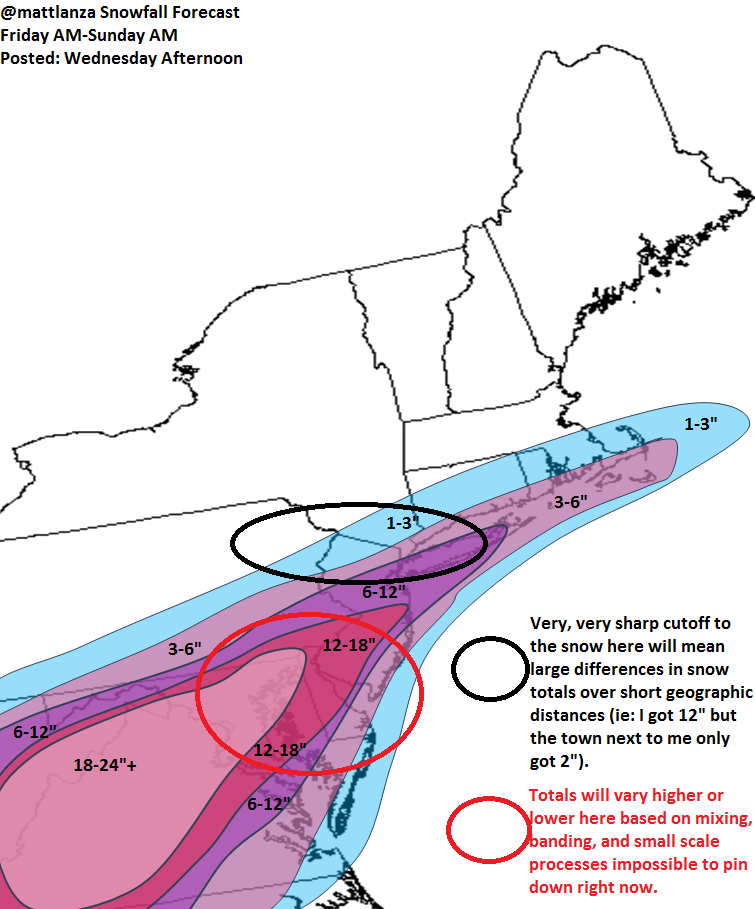
2.) It’s not sexy to say “we really don’t know for sure” ahead of time, but it’s a message that I think needs to be hammered home again and again, especially in storms like this. If you looked at a snow forecast map without context, you would have been shocked when you woke up on Tuesday. The fact that these storms are inherently difficult to predict should make this point a regular one in these events.

3.) The NWS experimental “expect at least this much”/”potential for this much” snow graphics have tremendous potential public value, but we need to figure out how to use them without being laughed at. The old “we could have zero to 15 inches” line is used as a joke by people. How do we make them actually see the value in that (can we even make them) rather than a punchline?

4.) Model snow forecast maps shared widely, loudly, and proudly will not change. We have to accept that info is out there, it sucks, it’s frustrating, but the beast has been unleashed and isn’t going back in the cage. How do we work in that environment without perpetually complaining about the fact that it happens during every storm?

5.) With point 4 in mind, how do we get people to focus on the bigger picture and not just the IMBY snow forecast? Is there a way to do it? What about mixed precip? If there’s mixed precip, how will it impact snow totals? And if there’s mixed precip, what other impacts could they cause? What about wind? What about coastal impacts? What impacts matter most?

I don’t personally like using myself as an example, but I’m going to grudgingly do it now. Back in my TV days, we had a ridiculously complex storm in Upstate NY, with a lot of mixed precipitation, issues with snow totals, ice totals, changeovers, etc. I went on air with one of the worst looking maps I think I’ve ever made. But for how I explain things, and how I figured our viewers would want to be told about things, it worked. It broke the DMA into sub-regions, and I spent some time explaining how each one would be impacted by the storm, etc.


Now, a lot of TV mets do this kind of thing already. And I’m not saying the way I went about it is the right way to do things. It probably isn’t. But it worked for the situation and it made me feel comfortable that when I got off air, I left people with as much as I knew and what uncertainties existed.

TV meteorologists are pressed for time, but with all the methods of reaching your audience today and all the information available, I think it’s incredibly important to leave as much as you know out there. Most people know this, but I think it’s a good point to re-emphasize.

6.) Naming winter storms continues to cause some debate, but that’s silly. That ship has sailed. I think it’s pretty clear that it pretty much works. I think it’s time to expand and standardize it, and I wish all parties would get on board with it.

7.) Forecaster gut and experience still matters. Based on data and what I’ve experienced, I knew on Sunday that this wasn’t going to get any easier. I prepared myself mentally to understand that there wasn’t going to be an ideal forecast put out during this event and that it was going to be a major challenge up to the last second to emphasize uncertainty. It allowed me to worry less about the forecast specifics and details and more on communicating the risks and problems. Even in an age where weather models are getting better all the time, I think your “gut” (ie: your experience coloring your perspective) is an underrated and vitally important forecasting tool.

8.) Everyone that’s a forecaster in meteorology needs to just breathe for a moment. People are going to be upset and angry over the forecast. Some people will be totally content and thrilled. It behooves no one to get cranky on someone complaining about the forecast. At the same time, it doesn’t make much sense to “celebrate” this forecast, unless you nailed it. This was a tough forecast; we all knew it going in. Sometimes, yes, people don’t listen, don’t read, only see what they want to see or hear what they want to hear. Sometimes we’re expected to go beyond what we’re capable of and beyond what the models and science allow to do in a forecast. There’s not much we can do there. Explain the uncertainties beforehand. Brace your audience for various outcomes. And accept whatever it may be at the end. You don’t need to apologize unless you feel like you had to, but you also don’t need to negatively engage people who may not necessarily be open to reason. It’s a humbling field, it’s a crazy world, they meet in 2017 online. Try to make the best of it.

Anyway, feel free to disagree with me and tell me I’m wrong. But I hope this can spur on some good conversation.

Visiting Vienna & Perusing Prague

Note: For those of you that only care about my posts on weather, you can ignore this if you choose. I don’t often write totally off-topic, but seeing as I wanted to share a recent experience with friends and family, this seemed like the simplest way to do so.

After a whirlwind 2 weeks, we’re back in Houston, and trying to adjust to an extra hour of daylight and some sense of normalcy. In conjunction with my wife’s science conference in Prague, we decided to make an adventure of it and visit both Vienna and Prague, my first trip to Europe, Denise’s second. I’ll walk you day by day and give you some brief text and lots of pictures.

You can click *most* of the photos to bring up larger versions of them. Hover over and if the finger pops up, you can do so. There are a few that you won’t be able to though.

Monday, March 14th: After having our bags arrive 6 hours after our plane did on Sunday, we sort of got off to a sluggish start. We started by exploring the Stephansplatz, or the plaza around Stephansdom (St. Stephan’s Cathedral). The view from the South Tower:

Vienna Morning From Stephansdom

It took 343 steps to get up here, but it was worth it. Vienna is beautiful from above. We then toured the inside of the cathedral, which was brimming with history. The South Tower took 65 years to build: 1368 to 1433. The interior was beautiful architecture and was dressed up for Holy Week:

Interior of St. Stephen's Cathedral

From there, we had lunch and then toured the Mozarthaus, or the only surviving residence Mozart inhabited while he lived in Vienna. We then visited another church: The Jesuit Church (Jesuitenkirche). Whereas St. Stephen’s was more gothic or Romanesque architecture, the Jesuitenkirche was decidedly Baroque. It was built in the early 1600s and remodeled in the early 1700s. Baroque style showed up a lot on this trip, and it’s easy to pick out by how flashy and ornate it is. The ceiling fresco is trippy with lots of depth:

IMG_4590
Portion of fresco inside the Jesuitenkirche

We concluded Monday with wienerschnitzel and a performance of Aida at the Vienna State Opera House.

Tuesday, March 15th: This was a museum day. We visited the Hofburg Palace, saw the Imperial Silver Collection, the Imperial Apartments, and learned extensively about Emperor Franz Joseph I and Empress Elisabeth (Sisi). Fascinating history. The Habsburg Empire has a pretty interesting storyline. The afternoon was spent at the Kunsthistorisches Museum. This is Vienna’s fine art museum, and it has a stunning collection of art. Overwhelming almost.

IMG_4603_edit
Denise in front of the Kunsthistoriches

From there we walked through Burggarten, a former royal gardens. A statue of Mozart now resides here. I enjoyed how flamboyant the designer made it. It seemed to match the personality of Mozart:

Statue of Mozart

7e4a74f4-76c0-4bd2-8854-a3fe17d0295d
Matt in the Burggarten

From there, we had dinner and toured the Haus der Musik that evening to learn some musical history.

Wednesday, March 16th: We started today at the Secession Building, which was interesting. It represented an interesting style war between traditional and modern, which I can see having an impact in a place like Vienna. The Beethoven Frieze was pretty cool though. After seeing the Naschmarkt (outdoor food/good market) and lunch, we visited the Karlskirche, a Baroque church just outside Vienna’s Inner Ring. We were able to see the dome and an overview of Vienna from a viewing platform:

IMG_4643_edit
Portion of the dome fresco in the Karlskirche

Karlskirche

From there, we walked through the Stadtpark, a park with statues on our way to the Museum of Applied Arts (Museum für angewandte Kunst) or MAK. The Star Wars: Identities roadshow was there, where we got to see original costumes, artifacts, and more from the movie series. We walked around Vienna a bit more before dinner at the Albertina, a modern art museum, which we enjoyed more than almost any museum in Vienna.

Thursday, March 17th: We got out and over to the Schönbrunn Palace in the morning. This was the summer residence of the Habsburgs. It was also the site of a meeting between Kennedy and Khrushchev in 1961.

Grounds of Schönbrunn Palace

IMG_4691
Denise outside the palace

Scenes from the Schönbrunn:

Schönbrunn Palace

Vienna Skyline

From there, we took to the Belvedere Palace back in Vienna. This is a Baroque palace complex, built for Prince Eugene of Savoy. Very picturesque gardens and setting.

Vienna and Belvedere Palace

That about wraps up Vienna. Friday was a transition day on the train between Vienna and Prague.

Saturday, March 19th: We started the day walking around Old Town Prague to get our bearings. Our first stop was the Powder Gate, or Powder Tower, which is one of the original city gates in Prague, separating the Old Town from the “New Town.” It was constructed in the 1400s.

View from Prague's Powder Gate

We then walked around Old Town, visiting the Church of St. James.  It was a Franciscan church destroyed by fire in the late 1600s and rebuilt as a Baroque church. We then went to see the Astronomical Clock in Old Town Square. The clock was installed in the early 1400s and puts on an hourly show that attracts THRONGS of tourists. From there we walked along the Vltava River to get some nice views of Prague Castle and the “Lesser Town” (Mala Strana), then walked the other side of the river to get views of Prague. Here’s a view of the Statue of Harmony and Old Town:

Prague from Mala Strana

We continued past the Lennon Wall and over the Charles Bridge back into Old Town.

IMG_4814
Denise on the Charles Bridge

The Charles Bridge is probably the iconic Prague landmark. It was built in the mid-1300s. After lunch, we walked across the river again, this time to the north to a fantastic place called Letna Park. The views were phenomenal.

Old Town Prague

Prague and the Vltava River

After taking all that in, we wrapped up for the day.

Sunday, March 20th: We began this day walking to the “New Town” part of Prague. New Town was developed in the 1300s, the youngest of the five older cities that make up the older core of Prague. We headed back to the river to get a view of a building known as the Dancing House, along with many other beautiful older buildings:

IMG_4872
The “Dancing House” and older buildings along the river

Legion Bridge and Prague Castle

We went to lunch and then changed hotels for Denise’s conference.

Monday, March 21st: With Denise in conference, I got to explore Prague a bit. This day was dreary, which was fitting, as I visited the Jewish Museum and the Museum of Communism, both interesting, but also sobering museums. The Jewish Museum is spread out over a wide part of Old Prague, with several parts to it. I started at the Spanish Synagogue, which had numerous exhibits on Jewish history in Prague and Bohemia, including a number of sobering items from World War II. I visited the Old Jewish Cemetery, where numerous important people from the 1400s to the 1700s are buried. The rain was fitting for pictures.

Old Jewish Cemetery, Prague

In the afternoon, I toured the Museum of Communism, learning much about Central Europe in the 1900s before returning to the hotel and meeting up with Denise for dinner.

Tuesday, March 22nd: Denise had a free morning, so we came back into Prague and walked around some more with Denise’s colleagues. We got to walk the Charles Bridge with only a handful of tourists, which was nice.

Prague Castle in the Morning


We then visited a museum dedicated to Johannes Kepler.

IMG_4920
Kepler Museum in Prague

During this morning, the news broke of the attacks in Brussels, so I opted to stay low after we went back to the hotel where Denise’s conference was being held.

Wednesday, March 23rd: Denise was back in conference all day, so I took a couple subway trains to the Vysehrad, a fort on the south side of Prague established in the 10th century. This was a very peaceful place to walk around, isolated from the busy city below.

Prague from the Vysehrad

The oldest building in Prague is located here, dating from the 11th century, the Rotunda of St. Martin:

IMG_4933_edit
The oldest building in Prague

After Vysehrad, it was lunch then back to the hotel to wait for Denise’s conference to wrap up.

Thursday, March 24th: After changing hotels one final time, it was off to explore Mala Strana, the “Lesser Town.” We started at St. Nicholas Church, which is a Baroque church, considered to be the greatest Baroque building in Prague, with one of the largest ceiling frescos in Europe:

Interior of St. Nicholas Church

We then walked up the Nerudova, a street lined with embassies, shops, and quaint old buildings.

Nerudova

We enjoyed a delicious midday snack here, featuring some of the best hot chocolate ever, as well as Prague chocolate cake (ganache, caramel, chocolate torte):

2a5b9bb0-8639-4383-b18f-056c52d2fc68

We walked through the Novy Svet neighborhood. The famous astronomer Tycho Brahe lived here in the year 1600.

IMG_5008
Tycho Brahe’s home in 1600

We meandered around the neighborhood a bit. The buildings were fairly idyllic.

Building on Loretanska

We worked up a hill to Prague Castle. The view of Prague was probably the best of the trip.

Prague from the Castle

We toured the inside of St. Vitus Cathedral, the behemoth overlooking Prague. The Cathedral was built over the course of 600 years, from the 1300s to the early 1900s. The interior:

IMG_5076

We walked the grounds of Prague Castle some more after St. Vitus. Here’s St. George’s Basilica, just behind St. Vitus Cathedral:

St. George's Basilica

The Basilica was originally built in the 900s, then rebuilt in the 1100s and given a Baroque makeover in the late 1600s.

One more view of Prague from the Castle:

Looking Over Prague

One Prague skyline oddity is the Žižkov Television Tower. It was built from the 80s into the early 90s, likely as a strategic Cold War technology. It now has practical utility but sticks out like a sore thumb amidst all the beautiful old architecture.

Žižkov TV Tower & Old Prague

We continued to walk around a bit before dinner.


Polish Embassy & Budding Trees

Swan and the Charles Bridge

That wrapped up our Thursday.

Friday, March 25th: Friday was a day to tie a ribbon around the trip. We cleaned up Prague Castle, visiting the interiors of some of the places we saw Thursday: St. George’s Basilica, the Royal Palace, and Golden Lane. One cool experience was to see the Windows of the Defenestration of Prague:

IMG_5136
Windows of the Defenestration of Prague

This is a fascinating period of history that ultimately started the Thirty Years War across Europe. They may just be windows, but the global history that was written here is incredible.

We continued our tour of the castle, eventually exiting through St. Wenceslas’ Vineyard, one of the oldest ones in Bohemia.

St. Wenceslas' Vineyard

From there, we visited the Franz Kafka Museum to learn a bit about the author’s life. It was a rather trippy museum, with lots of sensory overload going on, but interesting nonetheless.

6a7fe86e-91ed-4167-bc44-6fb62940b8ad
Denise in front of the Kafka Museum

We wrapped up with some souvenir shopping and a great dinner before packing up and getting ready to fly home on Saturday.

All in all, it was a really fun trip. I think we both found Prague to be a smidge better than Vienna. Part of that was the language (Austrians expect you to know German, whereas Czechs don’t seem to care). Part of that was the layout (The Vltava is more woven into the fabric of the city than the Danube is in Vienna). Part of it was also the history. Vienna has so many big ticket history items, but Prague can hold their own with them. And the stories in Prague are just as good, if not better than those in Vienna. It just felt like a more accessible city. That isn’t to demean Vienna a bit (if you have an opportunity go there, go). But we just put Prague on the next rung up.

Anyway, we hope you found this interesting and enjoyable. Thanks for reading!

Matt and Denise

ac66f31c-e879-4e34-9e4e-a941f931694c


Why Don’t We Listen?

Imagine for a moment that your state spends $100 billion each year. The nation spends roughly $3.5 trillion each year. Now, what if I told you that between your state and the nation, you could spend about $10 billion to insure against $100 billion or more in future losses? Does that sound like a good deal? What if I told you that in any given year though, you only have about a 0.2% chance of seeing that event you’re insuring against? Seems like a low risk. Do you think that $10 billion would be better spent elsewhere or not spent at all?

This is the issue Southeast Texas is grappling with.

On Thursday, one of the most important pieces of journalism written about the risk of a worst case scenario hurricane in the Houston area was published. The Texas Tribune/ProPublica mashup called “Hell and High Water” is worth your time. It describes, in detail, how a worst case scenario storm would play out in Houston. Without any mitigation or protective measures, the economic, human, and environmental cost of a worst case hurricane would be utterly catastrophic.

I read stories like this a lot. I’m a meteorologist. I work in energy. I’m pretty well acquainted with the concept of risk. And the more I read these stories, the more I ask myself: What in the hell are we doing?

It’s 2016. I fully appreciate the skeptical world we live in, where cable news is shouting at us 24/7 in hyperbolic terms about the next big threat. There is an element of hyperbole that exists in media, and  yes, sometimes in science too. Objectively, this idea of a worst case scenario storm is not hyperbole, not in the least. If Hurricane Rita in 2005 had tracked further south and west, or if Ike had been a tad stronger or bigger and tracked a tad further south and west, Houston would have been in a bad, bad place.

Yes, that’s 2 storms in the last 11 hurricane seasons that had the potential to be a worst case scenario for Houston. It’s not difficult to get monster hurricanes in the Gulf of Mexico. This area has been hit time and again by big ones. The concept isn’t new. It will continue.

Someone might argue that it’s just that “global warming alarmism.” Here’s the thing. Even if climate change weren’t real (it is). Even if sea levels weren’t rising (they are). This would *still* be as serious a concern as it is today.

So again, I ask: What in the hell are we doing? From this article, there are multiple groups spending millions of dollars to conduct multiple studies on this issue. And no one is committed to implementing any one of these plans. We have the information we need to get this thing moving. But what do we do? Because no major storm has threatened us since Ike, we sit on our hands, dawdle, and just hope and pray it never happens? People don’t see true risks until they’re realities. And over time, interest, concern, and motivation to act fades. Why are we still doing this in 2016, when we have the technology and capability to SEE risks before they happen? Think about that. We have abilities to understand and protect against disasters that even 50 years ago weren’t possible. It’s borderline miraculous.

Everything’s about saving money and gearing up for the next election. We see candidates for president arguing about the size of their hands and who can get married. Newsflash: We have clear evidence that we can mitigate potentially hundreds of billions in losses and unspeakable environmental and human catastrophe for what amounts to a drop in the bucket in terms of what we spend in this state and country. It would be great if we actually acted proactively and did something for the actual good of the people for a change. We have an incredible gift to see trouble coming. We also have a way to help minimize the toll. Why throw that away?

Read the article. Let it sink in. Then let’s get real about this risk.

I’m on Twitter: @mattlanza

Blizzard 2016 Thoughts

While it is still fresh, some thoughts on this storm.

1.) Give New Jersey the record it deserves. Being a native of New Jersey, I sincerely hope NWS investigates the 33″ Morris Plains and 35″ CoCoRaHS ob from Mine Hill. The 24 hour record for snow in Jersey was 32″ in 1915 in Rutherford. Based on the timing of snow obs at Morristown (MMU) and Somerville (SMQ), I suspect almost all this snow fell within a 24 hour period, and if the totals can be vetted and verified, a new state record should be established.

2.) Kudos to forecasters and communicators. While this was a challenging storm to pin down, I thought almost *all* forecasts for this event were incredibly well done. Everyone deserves credit. Unless you bought the NAM literally and took 1-2′ of snow to I-90 in Massachusetts, or unless you completely ruled out any chance of New York City seeing major snows, you did well in this event.

Between the uncertainty of the northern fringe gradient, the potential for epic snows around DC, the coastal flooding potential, there was a lot to communicate in this event. In my opinion, it was all done very effectively by so many within the weather community, from the NWS, TV, private sector, and social media types.

3.) It’s not the model, it’s how you use it. The amount of “modelology” surrounding this event was…annoying to say the least. So many people declaring the NAM victorious. At one point or another, most major global models indicated enough variability and risk on the northern fringe of the snow to include most of New Jersey and New York City within the “margin of error” so to speak. The NAM did not “win.” Again, judging by the map above, if you lived in Hartford or Springfield, MA or Boston and used the NAM, you had a lot of egg on your face. That’s not an inconsequential populous. Yes, the NAM was the more aggressive model in New York City and on that metric alone, it did well. But it didn’t win. No model “wins.” As a forecaster, it’s your job to objectively analyze the models…all of them…use every tool in your toolbox and make a call. If you blended the NAM with the RGEM and the Euro/GFS, well then you did *damn* good in this event with your snow forecast most likely. Likewise, if you outright dismissed the NAM because of last winter’s NYC debacle, you probably failed too. Recency bias will kill you. Many of us joked about the NAM being the NAM…and that is certainly exaggerated by some of us (including me…I do use the NAM daily when forecasting for Texas and Louisiana, and I have used it aggressively at times). It has a reputation for being sketchy, but I know most rational forecasters do use it and consider it.

We just can’t turn this into some training camp competition. If you use the NAM alone for the next event, I guarantee you your forecast will have serious shortcomings. Use all the tools; know their strengths and weaknesses in the areas you care about and leverage them to your advantage as a forecaster. And don’t fall prey to recency bias.

4.) Can we please figure out snow measurement? This is not a uniquely DC thing. It’s been a problem in New York City in the past. It’s a problem in Denver. It’s a problem in so many places.

Fully understanding weather and changes in climate in places is heavily dependent on having a long set of reliable actual measured data at those places. When we can’t depend on data being reliable, what use do we have for it? Why do we have a top 10 list of snowstorms? Why even bother? It’s time for someone to step in, standardize, and properly coordinate snow measurements at places. Cost isn’t an issue. The way I’d approach it: You know how many people would volunteer to do it correctly and love every second of it? Find a spot representative of a city (not an airport across from it and adjacent to a river), probably on state or federal property, and have a team of volunteers at the ready, able to coordinate, trained properly by NWS, and eager to jump in when snow is predicted. Adjust the site as needed for changes in population distribution, new construction, etc. We’re making this a lot more difficult than it needs to be.

5.) Storm names are fine, but we don’t need 30 of them. When they started, I was skeptical of The Weather Channel naming storms, though I believed from the beginning that it would be a successful venture. I think to this point, the storm name concept has worked. I get the frustration, but that ship has sailed and it’s not coming back. So we either do it right or we continue doing it this way, where there were at least 6-7 different storm name hashtags for the same storm. It’s a patchwork free-for-all, and it would be nice if we could streamline it. It would be better for everyone. The research argument is simple: How on earth can we find pictures and tweets from this event without searching through eleventy different hashtags? Instead of still griping about the fact that it’s done, come up with a way to do it better and get everyone to agree. It will be less difficult than anyone thinks, but to make it universal, it can only come from the NWS. It’s time.

Those are my thoughts. What are yours?

Follow me on Twitter: @mattlanza.

Snowzilla After Dark: It’s Happening

Here’s a special late night blog edition on Snowzilla, Jonas, Blizzard 2016, David Snowie, #winterstorm, whatever the heck name you give it.

What’s going on?

It’s snowing, a little faster and farther north than expected.

What does that mean for my final totals?

Well, it depends. Here’s a map, then an outline by region.

012216_snowforecast
My own (updated) revised snow forecast after reassessing SW Connecticut.

For Washington/Baltimore: Snow continues to steadily accumulate. Based on radar trends and model data, you’ll be in this for another 18-24 hours or so (as of 11 PM Friday). Final snow totals of 18-30″ or so seem reasonable, varying based on banding and any mixing (sleet to Fredericksburg as of this evening).

For Philadelphia/SW Jersey/N Del: Snow will rapidly pick up overnight, with totals of 12-18″ likely by tomorrow afternoon, continuing into tomorrow evening. Final totals probably 18-24″ average, maybe higher or lower in spots, depending on banding.

For Central/North Jersey and New York City: Snow will move in overnight. It should get north of I-80. Accumulations will probably range from 1-6″ along and north of the NJ/NY border, 6-10″ to I-80, 10-20″ between I-80 and I-78 (including the northern half of New York City), and 18-24″+ south of I-78, including the Southern half of New York City.

For New England: Still mainly a conversational snow, though the islands south of Massachusetts and Rhode Island could see decent snows. Nothing New Englanders cannot handle though. In Connecticut, it’s entirely possible the coastline gets hammered. But it will be a very close call. The “knife edge” between heavy snow and nuisance snow is further north tonight than it has been, and probably is somewhere between I-84 and I-95. My thoughts are to keep that south.

Why the shift north?

The storm itself seems to be tracking a little further north than anticipated. A few weather models alluded to this, though even they overstepped things a bit, trying to take heavy snow to Boston. Time will tell, but it seems like just a small scale shift in the grand scheme of things. I’ve been telling you that area in N NJ/NYC was on a knife edge all week. It just so happens a small shift envelopes them.

When does it end?

The storm should end from southwest to northeast late Saturday evening into Sunday early morning.

Follow me on Twitter: @mattlanza

Jonas 2016: ♫ People Are Blowing Snow ♫

If you haven’t thought of the Weezer song with regard to this storm, you’ve failed me. It deserves some parody. I tried. Oh well. Onward…

What’s changed since yesterday, Matt?

Not much. Other than bread and milk supplies in the grocery store being dwindled.

  • The storm is still coming.
  • It still appears the metro Washington, DC area is the bullseye for snow.
  • Coastal flooding is still a serious concern.
  • Blizzard Watches have been expanded to include much of Jersey, Philly, and the New York City area and Blizzard Warnings are posted for DC and Baltimore.
  • The northern edge of the storm is still going to drive most meteorologists to their local bar.

So how much snow for me?

Here’s my updated map:

012116_Snow_Forecast
My own personal snow forecast as of 5:30 PM ET Thursday. Again, not official, but my way of expressing it.

Again, I’ve highlighted the two key areas of uncertainty. The northern fringe is going to be a royal pain. There are some models that still bring good snow 8-12″ to NYC, but I don’t personally buy that scenario right now. Based on my experience, these sorts of storms have disappointed on the northern fringe, so I’d rather take a conservative stance there.

From Philly into Baltimore and DC, it gets complicated too. You’ll have a number of factors driving snow totals. I expect there to be issues with mixing in spots. Convection (thunderstorms…yes, thundersnow) will also be likely with this storm. In those cases, sometimes strong bands of snow setup over one place and effectively “rob” another of snowfall. So it’s possible that the final snow totals will not look this uniform. You could easily go from 18″ one place, to 10-12″ a couple towns over, back to 18″ a couple towns over from that. It’s chaotic. Snow forecasts aren’t meant to be simple.

What about the blizzard part?

Yes, Blizzard Watches and Warnings are posted all over. Fun fact: The amount of snow you see has 0 factor in whether or not a storm is defined as a blizzard. Why is that? My honest answer is because we like to make things difficult on ourselves as forecasters and communicators. That aside, it has to do with impacts mostly. A blizzard is supposed to mean wind, which limits how many storms meet the criteria of one…thus making it special and making it stand out.

For a storm to be a blizzard, it has to have 3 hours of winds sustained at or frequently gusting to 35 mph and visibility below 1/4 mile. That’s all. So we’ll see if that gets achieved, but based on model data, yes, it looks like blizzard criteria will be met at many places. For the sake of yourself, stay home Saturday.

How about the coastal flooding?

Here are the very latest tidal forecasts for Cape May, Atlantic City, and Sandy Hook. You can select others from those sites.

I heard this was going to be like Sandy?

Here’s something that agitated me today. I heard from several people somewhat panicked, thinking this was going to be Sandy II. Sandy was a 940 mb monster storm to the south of NJ, that was dragging days of water across the Atlantic Ocean directly into Jersey and New York. This storm will be strong, but it will be moving away from the coast. It won’t have nearly the same characteristics as Sandy did. Meteorologically, it’s like comparing apples to oranges.

But in terms of actual impact what does it mean? It means something worse than what you saw back in October with Joaquin, but short of what you saw in Sandy. It means a lot of water, yes, and major coastal flooding and a top 10 event perhaps. It means problems. The coast is more vulnerable now than it was 5 years ago.

That said, it does not mean mass devastation like was seen in Sandy. So you are right to be preparing and be concerned. But should you panic? No. Make your preparations as you would for any major coastal storm. Remain calm and heed the forecasts of the National Weather Service.

This will likely be my final forecast post on this storm. Thanks for reading and hope you have some time to enjoy the power of nature without being impacted too hard.

Follow me on Twitter @mattlanza.

Jonas 2016: Make Snow Forecasting Great Again

I don’t have any mom texts to run with today, but I do have a map. We’ll get to that shortly. Let’s break things down.

So what’s changed since yesterday, Matt?

Honestly? Not much really. We still have a storm. It’s still early in the game for snow forecast maps, but we can at least make some assumptions. We still have a major coastal flooding issue to deal with. We do have blizzard watches posted, among other NWS watches and warnings. All this means is “prepare for a snowstorm.”

Where are the watches and warnings?

Glad you asked. Here:

012016_snowwarnings
National Weather Service Watch/Warning Map as of 5:45 ET Wednesday

In the East, the purple are winter weather advisories, the blue winter storm watches, the pink winter storm warnings, and the green near DC is a Blizzard Watch. Consult your local NWS office website for what it all means exactly, but the bottom line is a major winter storm is going impact places from Central Arkansas to New York City.

Has the coastal flooding idea changed?

Not really. There have been some forecast tweaks, but overall you’re still looking at a top 5-10 coastal flooding event along the Jersey and Delaware Shore, and possibly for places south and north of there also. Basically, this should be the worst you’ve seen since Sandy. It should *not* match Sandy in most places (though in Cape May and Delaware it’s going to come close), but I don’t want that to diminish the significance. The coast is far more vulnerable in spots now than it was then, so just because it’s not Sandy II, does not mean it’s going to bust. This is a big deal. Here are the very latest tidal forecasts for Cape May, Atlantic City, and Sandy Hook.

This flooding event will rival some of the great nor’easters in memory. Think Ash Wednesday 1962, Halloween 1991, December 1992. This storm will have elements of those storms and it should be treated seriously if you live on the coast or back bays.

Alright, so talk to me about snow.

Here is *my* snow forecast thinking. This is not an official forecast. It’s subject to change, and you should always consult the official NWS forecast or local TV for the most up to date info. Yes, I’m a native of Jersey and spent 5 winters drawing snow maps in Upstate New York when I worked in Syracuse and Utica, but I live in Texas now. I can only do so much.

012016_Snow_Forecast
My snow forecast as of Wednesday evening. Not an official forecast, just my own opinion.

What do I think? Some key points.

The northern fringe of this storm is an absolute nightmare. If you live north of I-195 in NJ or I-76 in PA, this is going to be an incredibly difficult forecast to peg down. The tight gradient in snowfall that I spoke of yesterday is going to wreak havoc. A 20 mile shift in track of the storm (highly possible) could lead to a 6-12″ difference in snow totals, if not more. This is going to be a big problem for North Jersey, possibly the Harrisburg metro area, New York City and extreme southern Connecticut/Long Island.

The Jersey Shore is oscillating between a total mix scenario and a thumping snow. I don’t think this is like the storms of 2009 and 2010, where coastal South Jersey absolutely raked in snow totals. This will be more complex, and I’ve cautiously gone about 3-6″ there, but I do see risk for higher amounts depending on the exact final track.

The thump zone for this will be Northern/Western Virginia through DC and Baltimore. While I don’t expect a uniform 18-24″ in that zone, I do expect some locations to push 30″, contingent on mixing and thunderstorm potential. Other areas will see less than 18″. That’s the nature of snowstorms like this.

Yes, thunder is going to be likely from VA through NJ with this I think.

Winds of 30-50 mph are likely, and some gusts could be even stronger. This will create blizzard conditions. I would not be shocked to see Blizzard Watches expanded tomorrow.

Anything else I should know?

Snowstorms are fun. This one is going to be big, massive, and historic. While fun, it has a very serious element to it that should be respected. If you have plans on Saturday, I would strongly consider rescheduling them. Heed the warnings from NWS. They’re not just throwing this stuff out there. It’s serious.

And please consider taking pictures of something other than your patio furniture. Seriously. Get creative!

Follow me on Twitter @mattlanza.

Your East Coast Winter Storm Run-Up Survival Guide

As a forecaster and communicator, I try and approach my audience a lot like I would my mother. Would my mom understand what I’m talking about? Sometimes I deviate and get nerdy; we all do. But when it comes to the forecast details, it has to be simple, clear, and easy to understand.

So my mother sent me an interesting text message today. She said:

Ok. I’m getting anxious. Or curious. I’ve heard so many maybe this or maybe that’s. I want the truth. I’m sick of speculation.

That’s such a great mom text.

In the run up to this major East Coast winter storm, blizzard, Winter Storm Jonas, whatever you use to describe it, you’re going to get a ton of this speculation.

So today, you’re all my mother, and consider this my survival guide for you.

What’s going on here?

The weather models have been hooked on this idea of a major winter storm in the Eastern US for awhile now. There is good agreement among all the various models we use that something is going to happen. Someone’s getting a major storm.

So how much snow am I getting?

No one can answer that question today unfortunately. What we know is that a number of factors are going to contribute to this storm being loaded with moisture. In other words, someone is going to get a *lot* of snow. It’s just not possible to say who that is yet.

Right, right, I get that, but give me your best shot.

This storm is big, slow, and it has a number of complex parts to it that will make it difficult to peg down until we are closer in than usual. But, some trends have evolved in the last couple days that lead us to believe a few facts about this storm.

First, it will be a *big* storm. That means even if you don’t get snow, you may get impacts. It will be slow moving. It will have wind…lots of wind. It will have major, major coastal impacts. Depending on track, we could be looking at a top 5-10 coastal flooding event for folks from the Jersey Shore into Virginia perhaps. That is a serious issue.

But what about snow? The storm has slowly trended south on the weather models. Additionally, it has a very, very sharp gradient on the north side. In plain English? If you live on the northern fringe of this storm, there’s going to be a razor thin margin between major snow and conversational snow.

Here now, a map of where I think things stand as of Tuesday afternoon. Remember, this is subject to change.

011916_snowrisk
My Own Tuesday Evening Snow Synopsis for the Weekend

The trouble is in New England, New York City, and Northern NJ. The models show a tremendous cutoff in snowfall here. The next map is a weather model’s output for precipitation (liquid, not snow). I’ve focused on the NYC area.

011916_precip
18z GFS Model Precip for New York City area (Weather Bell)

Why am I showing this? Notice how in the Central Jersey area, the model spits out about 1.5″ liquid. Go 50 miles north from there. So, like Orange County, NY? About 0.5″ liquid. A 1″ liquid is roughly equivalent to about 10″ of snow. So 10″ snow difference over 50 miles, and the reality is likely that it will be even sharper than this. You’re talking about (surprise!) a major difference in snow totals likely over a short distance over a major population center.

Bottom line in all this: I have higher confidence in heavy snow hitting Virginia and probably DC right now than I do for the Northern half of NJ, New York, or New England. I don’t focus on North Carolina much since the majority of my family and friends are between DC and Boston. But this has potential to be a big storm in a good chunk of NC also.

Alright, so when does all this unfold?

Snow should start in Virginia as early as later Friday morning, and it probably won’t end until about Saturday night. In Philly, it’s a Friday afternoon start and late Saturday night finish. Add a couple hours to all this as you go north to NYC. I have lower confidence in anything further north, so I won’t speculate beyond this.

What about this coastal flooding?

Yeah, this one goes unchecked sometimes. Snow is way sexier, but this is way more damaging potentially. The NWS office in Mount Holly has done an excellent job highlighting this risk. If you look at storm surge guidance for Cape May, NJ, you’ll see the first high tide cycle impacted late Friday ends up at a water level of about 8.5-8.7 feet. Sandy saw a tide level of 8.9 feet there, October 29, 2011 was 8.7 feet, the December 1992 nor’easter was 8.6 feet. An 8.5 foot tide level would rank in the top 8 all time at Cape May. This one’s big. It’s like a 90’s throwback nor’easter.

011916_Cape May
Cape May Surge Guidance shows a tidal level over 8.5′ Friday night/Saturday AM. This would be a top 10 event without much trouble. (NOAA)

If you live along the coast or Back Bays of New Jersey, Delmarva, Virginia, you should begin planning for the possibility of 2-3 high tide cycles like this. If the storm track shifts a bit or the intensity changes, we could see these values change. It’s a fluid forecast, but it’s a serious issue along the coast. Follow your local NWS office for info and guidance.

So will it be a blizzard?

Maybe for someone. It’s entirely possible, but specific criteria must be met regarding wind speed and visibility. It’s too soon to say exactly where and who or how long, but it’s a distinct possibility.

That’s all for now. Feel free to ask any questions and follow me on Twitter at @mattlanza.

I Am The Establishment

An editorial comment.

In this winter of incredible discontent thus far, Eastern US weather weenies have become, quite simply, insufferable. I’ve seen name calling, rage, anger, and a serious dose of voodoo weather forecasting. Because the forecast continues to verify warm, despite some prophetic claims of cold coming, the army of ticked off weather weenies grows angrier and more vocal toward professionals in the field on Twitter. Ten years ago, it used to be weather forums, and although there would be ridiculous forecasts and posts from the weather weenie community, there was at least some decorum most of the time. I’ve grown a bit disheartened by the personal direct attacks at those in the meteorology community. Some of these attacks come from budding meteorologists.

Most of those in the weather enthusiast/weenie community are awesome people. But the vocal minority have gotten loud. And I will say: This isn’t limited to the weenies of the East. There are professionals in our field that also engage in this sort of deplorable behavior. I’m not going to admonish anyone specific or stand over here yelling “play nice!” But it would be nice if everyone could play nice and take it easy on one another. Calling someone a name won’t make it snow any more in your backyard. Taunting the weenie community won’t make them realize the snow deficit isn’t ending in the near future. So everyone should step back and chill.

But it got me thinking. Why is the hate so evident and vocal this year? I have a theory. We (collectively the degreed meteorologists or professional meteorologists employed in the private sector, NWS, or media) are “The Establishment.” What’s been a key component of the 2016 presidential campaign? A revolt against The Establishment. We generally go by the book and play by the rules. We fraternize with one another. We’re friendly. We’re employed or between jobs. Most of us have degrees and went through the calculus, dynamics, etc. We believe in meteorology first above modelology. Our forecasts are considered “official.” Most users of our forecasts have no problem with this. Some may seek another opinion here or there, but for the most part, they trust us.

But then you have a subset within the field of voices who have gone their own way and charted their own course. Many of them haven’t done the hardcore math or have degrees in a field even remotely related to meteorology. But many of them have tirelessly studied it as a hobby. Many of them are exceptionally talented weather forecasters and do an extremely good job feasting on the weather niche that exists in social media. The majority are well-intentioned, smart people, and a handful are better at forecasting and sniffing out patterns than some of the best in the field. Yet, a few are full-on weenies that think they use meteorology to make one plus one somehow equal three. These false prophets are the ones that the most vocal and vile of the weenies turn to in times of misery…grasping for hope in a hopeless pattern. To these weenies, we are The Establishment and the false prophets are the grassroots voices of hope. I believe they feel some of the false prophets are marginalized and kicked aside by those of us in The Establishment, and they feel a need to defend their people…similar to how some anti-establishment candidates are supported in politics. Thus, you see a revolt.

I don’t know what it means ultimately. This problem won’t go away, and it’s not something we should completely ignore as a meteorology community. I think better understanding and tolerance all around is needed. But I think if you frame your approach to this divide within the weather enthusiast community as thinking you’re just part of The Establishment, you may be able to devise a different approach to dealing with it. It’s just food for thought.

El Nino Rains: Comparing 2015 so far to other beasts of the past

The fever pitch of El Nino headlines and articles isn’t slowing down. In fact, it’s only growing:

El Nino Fever Pitch

It comes mostly with speculation, preparation, and wonder. Some of the headlines are ridiculous (just go back through photos on my Twitter timeline). Most are reasonable. But it’s news. And it’s clearly a high impact weather phenomenon.

So it begs the question: How’s it doing? Is El Nino behaving like it’s supposed to? Specifically with regard to rainfall. Remember, this El Nino event is a strong one. In fact, it’s the strongest since 1997, and in some respects, it may be the strongest on record. So we have a pretty clear set of analogs to look at and see if this year fits the mold.

Judging by the temperature forecast for the next 10-15 days, the pattern seems to be mostly behaving like a strong El Nino should in December. How about rain? Let’s look back at other actual strong El Nino events and see where 2015-16 is falling relative to those events, specifically in terms of rainfall.

A caveat here: Remember, it’s early. Winter is a marathon, not a sprint. Because something looks one way on December 8th, doesn’t mean one month from now we’re going to be in the same boat. But there are a few interesting nuggets to pull out of this, and I think it’s mostly a good idea to give people some perspective on certain story lines.

Just as a note, my definition for “strong” El Nino events was using a blend from Jan Null’s list post-1950 and Klaus Wolter’s list pre-1950, as well as some “artistic liberty.” Not everyone agrees on the perfect definition of what a strong El Nino is, but hopefully I captured the majority. I’m tracking rain from July 1-June 30.

Southern California

When people think of El Nino, many think of SoCal. You know, mudslides in Malibu, etc. I believe the mayhem of 1997-98 and subsequent personification by Chris Farley has set a level of expectations.

Thus far, 2015 is behaving pretty much about where other strong El Nino events have done in Los Angeles:

Los Angeles Rainfall

Every strong El Nino event back to the 1800s has had normal or above normal rainfall in Los Angeles. Thus far, thanks mostly to a freak wet event in early autumn, Los Angeles is indeed above normal. It is worth noting, that 2015-16 wouldn’t be the only strong El Nino year to see a “freak” early autumn rainfall event followed by a prolonged period of dryness into December. So if people are wondering where the rain is, wait a few more weeks. We are entering the ramp up period. If things don’t start picking up by late month, then we can start to worry.

Northern California

Northern California is a conundrum during strong El Nino events. Historically, San Francisco is split between above and below normal rainfall, so it’s tough to say too much at this early stage. That said, it is worth nothing, that as of right now, this El Nino is on the lower end of the envelope in terms of rainfall in strong El Nino events in the Bay Area:

San Francisco Rainfall

Like Los Angeles, it’s still early. The ramp should start soon if we’re going to go above normal, so again, if things don’t perk up by late December, it might be time to plan on a normal or drier than normal winter at best.

Washington/Oregon

This is where it gets interesting. For the most part, the El Nino signal in the Pacific Northwest is somewhat mixed. You get dry years and you get wet years. Usually, however, you don’t have a super wet year when there’s a strong El Nino.

In Portland (where the data is only available back to the 1957-58 El Nino) no strong El Nino has been wetter than normal. Seattle is mixed from slightly above normal to way below normal. So far in Seattle? It’s the wettest strong El Nino to this point on record, and it’s not even close. This autumn has been incredibly wet so far.

Seattle Rainfall

If we keep up at this rate (and the current forecast implies this), this will quickly become one the wettest, if not the wettest strong El Nino event on record in Seattle.

Great Basin/Rockies

In Denver, the bend is toward a wetter than normal outcome in strong El Nino years, but it is mixed. So far, Denver has been mid-pack for strong El Nino events.

Denver Rainfall.png

Salt Lake City is a bit more mixed, split almost evenly between wetter than normal and drier than normal (82-83 was a beast there). So far, we’re doing middle of the pack there also.

SLC Rainfall

It will be interesting to follow this as we go through the cold season. I’ll likely be tracking this, as it’s good to establish where this El Nino event falls. For everyone, it will probably be different. But thankfully we have a useful sample in a number of places to utilize.